Reevaluation defines attractive areas in Peru's Ucayali-Ene basin
This project presents a regional geophysical and geological evaluation to identify new play types in the Ucayali-Ene basin of Peru through the interpretation of digital seismic and well data, defining the stratigraphic and structural framework of the basin, combined with an analysis of the exploratory drilling since 1990.
The project called for compiling a data base of standardized geological data, quality control of over 15,000 km of 2D SEG-Y seismic data, synthetic seismograms tied to seismic and wireline logs from 40 new field wildcats, and an Access well data base.
The regional evaluation of the Ucayali-Ene basin developed a regional stratigraphic and tectonic framework to be used as a building block for future studies.
The Ucayali basin is one of several underexplored sub-Andean basins with mixed exploration success. It is a polyhistory basin, with extensional and compressional tectonics, where older, Paleozoic normal faults were rejuvenated as reverse faults controlling much of the structuring and hence the trapping mechanisms.
The western boundary of the basin is dominated by a thin-skinned fold thrust belt (FTB) along almost its entirety, interrupted by the Shira Mountains south of which the giant Camisea fields were discovered. The FTB comprises the most attractive exploration area, particularly the Camisea and the Oxapampa areas where significant gas columns were tested. In the foreland are still a large number of undrilled structural and stratigraphic plays.
The principal reservoirs are in the Cretaceous, the Permian Lower Nia, and Ene found as major contributors to the reserves in Camisea.
Previous work
Well Ganso Azul 1 discovered Agua Caliente field with 43° gravity oil in the Cushabatay formation in 1937.
It was followed by discovery of 37° gravity oil in Vivian at Maquia field in 1957 and gas-condensate in the Cushabatay formation in Aguaytia field by Mobil in 1962.
In the 1980s, the Shell San Martin 1X and Cashiriari 1X wells tested 41 MMcfd of gas and 1,626 b/d of condensate and 56.7 MMcfd and 1,553 b/d, respectively, from a Cretaceous/ Permian section, proving world-class reserves in the Camisea fold thrust belt (FTB).
Shell discovered gas-condensate in Pagoreni 1X in the Camisea area in 1998. Perupetro SA took over Petroperu's former role in exploration contracts negotiations in 1993. Pluspetrol and partners won development of the Camisea project in 2000.
Production
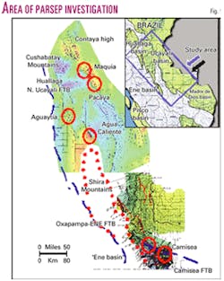
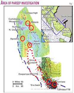
Three oilfields (Maquia, Agua Caliente, and Pacaya) and five gas-condensate fields (Aguaytia, San Martin, Cashiriari, Pagoreni, and Mipaya) have been discovered (Fig. 1).
The Camisea fields (13 tcf gas and over 500 million bbl of liquids) are scheduled to be on production in the near future.
Geology-stratigraphy
Basin description
The basin extends 650 km from Marañon to the Madre de Dios basin and 250 km in width from the FTB to beyond the Brazilian border (Fig. 1).
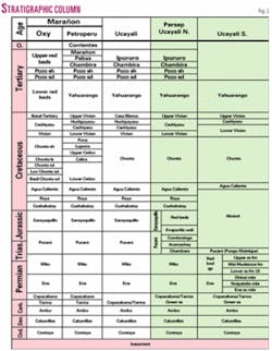
A 5,000+ m thick sedimentary section of Paleozoic to Recent ages was deposited overlying basement (Fig. 2). The dominant structural form is major basement-involved thrusting, mainly along reactivated Paleozoic normal faults and detached thin-skinned thrusts along its western margin.
Regional geology
The Ucayali sedimentary sequence merges with the Marañon, Madre de Dios, and Acre and Solimoes (in Brazil) basins.
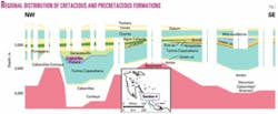
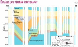
Parsep attempts to standardize the stratigraphy to keep it in a consistent digital database to facilitate mapping and interpretation, especially with changes made in Camisea. Paleozoic constitutes a potential play in the basin. Fig. 3 is one of the 10 stratigraphic cross-sections that include all new field wildcats.
Two regional tectonic systems, the pre-Andean and Andean Systems, control the geological evolution of the sub-Andean basins of Peru.
Pre-Andean System
The pre-Andean System reveals complex tectonics, including pre-Cabanillas rifting(?) and peneplanation and a late Permian uplift and erosional episodes.
The Contaya formation of Ordovician age overlying basement initiated the pre-Andean cycle. The Silurian cycle merges with the Devonian Cabanillas Group, identified by seismic in thick isolated half grabens (600 msec, Fig. 4). Coarsening upward sequences end in flooding events with organic-rich source rock facies.
The Late Devonian Eo-Hercynian compressional event established the N-S structural trend in the basin, a trend affected by Andean structural inversion.
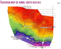
The Permo-Carboniferous rests unconformably over the Devonian Cycle and-or basement in uplifted areas. It began with the Ambo Group, a continental to shallow marine siliciclastic unit, with organic rich interbeds, the main source rocks for the gas-condensate in Camisea. In the Parsep seismic map (Fig. 5), the Ambo Group thickens dramatically (600 msec) past a major hingeline in the Camisea area, in an area where it is one of the main detachment surfaces.
The clastic-rich transgressive Tarma formation with its basal Green sandstone with good reservoir potential is overlain by massive shelf carbonates with dark gray shales and anhydrites of the Copacabana Group.
Copacabana is conformably overlain by the late Permian Ene formation/Red Bed Group, well defined in Camisea (Fig. 6), whose deposition was interrupted by a regional uplift and a pronounced unconformity that marks a first order sequence boundary in late Permian.
The Ene formation has three to four members. The basal Ene sandstone and Noipatsite members are two sandstone bodies overlying Copacabana. In the Huaya 3X and Orellana 1X wells, a 160-200 m thick sandstone overlying Copacabana is equivalent to these units.
The basal Lower Sandstone or Lower Nia formation of the Red Bed Group consists of 90-130 m thick eolian coarse-grained arkosic arenites with good porosity that contain gas-condensate at Camisea. The unconformity at the Base Cretaceous left this unit in contact with Agua Caliente in Camisea.
The Andean System
The Andean System along the Peruvian Eastern Range was initiated with the beginning of subduction along the Pacific margin during the Pangea break up in late Permian to early Triassic time. It is preserved in the western and NW extremes of the Ucayali basin.
The synrift Mitu continental red beds were deposited in isolated rift segments overlain by Triassic to Jurassic-aged marine to transitional carbonates and evaporites of the Pucara Group with the Aramachay formation representing the maximum flooding event.
The Pucara marine sequence of the FTB changes to a continental facies in its eastern subsurface occurrence. The eastern Pucara (and Sarayaquillo) shoreline has a N-S trend from west of the Contaya arch to Agua Caliente field north of the Shira Mountains.
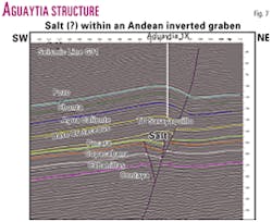
An evaporitic sabkha environment developed at the transition between Pucara and Sarayaquillo. Evaporites were drilled by the Oxapampa 7-1 and Chio 1X wells and outcrop extensively in the in the FTB for over 700 km. Parsep interprets that the basin was segmented into a series of Paleozoic wrench related depocenters and formed inverted an half graben (Aguaytia, Fig. 7).
Deposition of the Middle to Late Jurassic continental red beds of the Sarayaquillo formation ended with the regional Nevadan unconformity over which lies sediments of Cretaceous age.
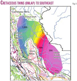
Cretaceous deposition consisted of a major transgression/regression cycle that left a westerly thickening wedge of fluvial to marginal clastics punctuated by marine carbonate sedimentation. The Cretaceous section thins from NW to SE as it progressively onlaps Paleozoic (Figs. 4 and 8), and the Cushabatay and Raya formations disappear in a NNE-SSW wedge.
Parsep extends the Upper Agua Caliente formation to the Camisea area to include Shell's Basal Chonta sandstone and Upper Nia. Chonta represents the maximum flooding surface with excellent seal character. Vivian represents the end of Cretaceous deposition with a quartz arenitic complex with good intergranular porosity.
The Agua Caliente and Vivian are the reservoirs for the gas-condensate at Camisea. The Cretaceous deposition terminated with the arrival of the first pulses of the Andean Orogeny in Late Cretaceous beginning dominant foredeep molasse deposition punctuated by a marine transgression (Pozo shale).
Structural analysis
Devonian to late Tertiary tectonic features influenced sedimentation at various stages of basin development and gave the basin its present geometry. Six structural profiles across the basin show several of these features.
Devonian faults
Two ages for Devonian faulting can be documented in the South Ucayali. The earliest represents extensional faults that created deep half grabens during the Devonian (or earlier) with thick pre-Carboniferous sediments, as local kitchens of Cabanillas shales (Fig. 4). The second is a compression faulting in response to the Eohercynian in Late Devonian that produced N-S oriented faults.
Late Paleozoic structures
This late Permian extensional event is one of the most significant tectonic events from a hydrocarbon exploration perspective.
The Contaya arch and Shira Mountains were initiated as significant horst blocks, and their current NW and NNW orientations reflect Andean imprint. Thick sequences of Carboniferous to late Permian sediments containing source rock and reservoir sequences were protected in grabens from later peneplation by early Cretaceous erosion.
Development of subtle highs and lows influenced deposition environments and reservoir development (Pucara in Shanusi 1X). The faults have N to NNE orientation and were locally reactivated during Andean Orogeny as inversion features (Aguaytia).
Late Andean structures
Most wells in the basin drilled Andean aged structures with strong surface expression. In the northern Ucayali basin, the Pisqui-Coninca-Rashaya Sur and Maquia-Cashiboya trends represent very distinctive NW Andean structural trends. Production was established only on the latter trend.
Cushabatay Mountains
The Cushabatay Mountains, a Pucara prospect, is a prominent structural feature interpreted by Parsep as a half graben filled with a very thick succession of Mitu, Pucara, Sarayaquillo, and Cretaceous. It developed concurrently with the NW-SE trending horsts and grabens seen in the SW Marañon basin in response to the Permo-Triassic extensional event and inverted in late Tertiary.
Contaya arch
The Contaya arch is a NW-SE trending horst of Permo-Triassic and Jurassic age uplifted by compression in the Neogene. Tankard postulated an origin along the NE trending Contaya shear zone.
Shira Mountains
The Shira Mountains is the most prominent tectonic element in the basin.
Its subsurface continuation to the north aligns with the Sarayaquillo and Pucara eastern wedges that divide the Ucayali into a deep western basin. In the shallower eastern and larger basin Cretaceous overlies Paleozoic.
The Shira Mountains is a late Permian basement-cored horst block with a significant uplift in late Neogene. It acted as a buttress to the eastward advancement of the Oxapampa/Ene and Camisea FTBs (Fig. 1).
Western fold thrust belt
The FTB of the north and central areas is offset to the east by a northwest trending lateral ramp after which the fold belt trends N-S to near the Oxapampa area with west and east verging thrusts fronts and overturned beds.
The northern edge of the Oxapampa/Ene FTB segment is offset to the east by another lateral ramp whose eastward leading edge is the San Matias fault and terminates into the Shira Mountains. South of the Oxapampa wells, the FTB collides with these mountains continuing to the south into the Ene basin. Parsep interprets two major thrusts with a detachment surface near the base of salt and Mitu levels.
Camisea area
Recent acquisition of 3D seismic may refine the geology interpreted by Shell.
Anticlines of the Camisea area are ramp fault bend folds with the principal detachment surface in the Ambo-Devonian section. Advancement of the thrust front was controlled by a depositional hingeline in Ambo (Fig. 5).
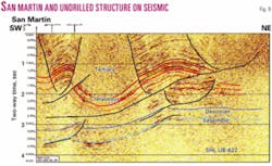
Termination of the Camisea FTB against the Shira Mountains is through a gradual horizontal and vertical diminishing of fault throw from east to west, roughly coincident with the Tambo fault. This decreases amplitude of anticline trends to the east as San Martin, Cashiriari, and an undrilled structure to the east (Fig. 9).
Structural profiles
Six structural cross sections cover the main structural elements in the basin.
Geophysics
Seismic interpretation was carried out successfully in two halves, north and south of the La Colpa/Runuya wells. No detailed mapping was accomplished, but the overall structural elements are clear in the mapping.
Maps plotted
Seismic mapping was performed for five structural horizons and three isochron intervals for each the South and North Ucayali.
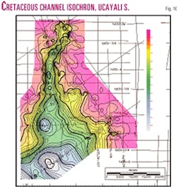
All mapped horizons exhibit a N-S trend, with shallow NE-SW trends affected by SE-NW trending faults in the Ucayali North. In the Ucayali South, there are common characters to all the horizons above the Devonian. In the northern part of the Southern Ucayali area, high-angle reverse faults with small throw are re-activations of older normal faults marking the edges of grabens and half-grabens. A large Cretaceous channel occupies one of them (Fig. 10).
Time structure maps
The Pozo formation is a regional marker in the Marañon and northern Ucayali basin, and good time equivalent reflectors allow extrapolation farther south. It exhibits the same features as the Base Cretaceous.
The Base Cretaceous is a recognizable unconformity on seismic data in the whole basin (Fig. 1). It shows two large structures, Rio Caco and Rashaya Norte, with closure of 100 ms. This horizon shows good rollover into the San Martin fault.
Block faulting of the basement controls much of the overlying structuring and faulting along grabens and half grabens controls younger rejuvenated reverse faults.
Isochron maps
The Pozo to Base Cretaceous and Base Cretaceous to Contaya isochrons show thickening dramatically from south to north (400-1,000 ms TWT in the former). The latter indicates a Paleo structural high in the Rashaya structure (100+ ms closure).
An ancient depression running through the center of the Aguaytia structure indicates Andean inversion. As this is the only productive anticline in this immediate area a relationship is implied.
A salt isochron map shows the distribution of the evaporitic unit. The Upper Cretaceous to Tarma isochron map indicates a general thinning to the northeast, since there is a very thick late Permian unit in the southwest.
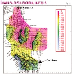
The Devonian-basement isochron (Fig. 11) is the most significant map of the present interpretation. It shows the graben system controlling the channel feature, a major half-graben feature in the eastern part and major thickening to the south.
Well summary
The report contains an evaluation of the 10 wells drilled between 1990 and 2002 and for the Cashiriari 1X and San Martin 1X wells.
Petroleum geology
Geochemistry
The Parsep group did not evaluate in detail the geochemistry of the Ucayali basin. One of the objectives of this study was to identify potential kitchen areas for the known source rocks.
Source rocks
The Ucayali basin has multiple source rocks in the Mesozoic and Paleozoic sequences.
Commercial hydrocarbon production and most wildcats with shows point to their presence. The Triassic/ Jurassic Pucara Group is source rock for the oil and gas in the southern Marañon and northern Ucayali basins. The Late Permian Ene formation is the source of the oil in Agua Caliente field.
Excellent quality Ene source rocks have been found in the Ene basin. The Ambo/Tarma-Copacabana formations marine shales and carbonates have TOCs of 1.0 and over 8.0 wt % mainly humid organic matter with potential gas and oil generation capabilities. Ambo has sourced the Camisea gas-condensate fields.
Reservoir and seals
Reservoirs include the Cretaceous Cushabatay, Chonta, Upper and Lower Vivian, and Cachiyacu formations.
The Camisea area has proven reservoirs in the Cretaceous Vivian, Chonta, and Agua Caliente and in the Permian Lower Nia and Ene.
Other targets include the Green sandstone, the deltaic sandstones of Ambo, and the intratidal carbonates of the Pucara Group and Copacabana. Regional seals are in the Lower Tertiary, Cretaceous Cachiyacu, Huchpayacu, Chonta, and Raya formations, in the sabkha evaporates, and in the Permian Shinai mudstone.
Prospects-leads
Although the study was intended to investigate new play concepts, two structural prospects and two stratigraphic leads were defined.
Rashaya Norte
Parsep interprets the structure as a Paleozoic horst block where Cretaceous overlies Cabanillas on the crest. It is much larger than Rashaya Sur, where a well had gas shows and fluorescence in Raya, Cushabatay, and Pumayacu, and a DST in Upper Raya tested salt water and 40.6° gravity oil.
Rio Caco Sur
The Rio Caco Sur prospect may be in an Ene inlier.
Stratigraphic leads
The Cushabatay South Pucara lead is defined south of the Cushabatay Mountains based on the concepts of high-energy carbonates or even reef deposits developed for the Pucara in the Shanusi 1X well that found gas-condensate on a paleo-horst block.
A large Cretaceous channel play is interpreted cutting and filling into a Paleozoic tectonic depression. There is evidence of high amplitudes in the channel.
This article is a summary of the Ucayali/Ene Basin Technical Report, one of five Parsep evaluations of the hydrocarbon potential of the Peruvian Sub-Andean Basins. Parsep is a joint technical agreement between Peru and Canada. Teknica Overseas Ltd., Calgary, and Perupetro SA performed the technical work. Other evaluations include the onshore Huallaga, Santiago, and Marañon basins and the offshore Trujillo-Salaverry basin.
The authors
Elmer Martinez Gonzales (emartinez@peru- petro.com) is senior geophysicist with 23 years of experience in seismic interpretation and acquisition. He has been with Perupetro SA since 1999 as coordinator of the Parsep Project, working in Peruvian hydrocarbon basin evaluations. Before that he worked with Sismica SA in Peru and Israel and in the Petroperu exploration department. He is a graduate of the geology school, Universidad de San Marcos, and Norwegian Technologist University.
Justo Fernandez C. (jufernandez@amauta .rcp.net.pe) is senior petroleum geologist with 34 years' experience. He has worked since 2001 in the Parsep-Perupetro Group. His geological experience includes basin evaluations and selection of new ventures in Peru and Guatemala, exploratory drilling in Peruvian, Colombian, and Guatemala/ Mexico basins, and in field development and production in Peruvian basins. He is a graduate of San Marcos University and Indiana University.
Ysabel Calderon ([email protected]) has worked for Perupetro since November 1999 as a geologist in Parsep. She worked for Geosurvey SA in geodesic and environmental studies and with Occidental in 1997-98 as a junior geologist. She has a geology degree from San Marcos University.
Carlos Galdos ([email protected]) is a geophysicist who worked with the Parsep team since November 1999. He previously worked with Occidental Peruana Inc. and is a graduate of San Agustin University.
