The petroleum system: A fundamental tool
The petroleum system (PS) is today a paradigm of hydrocarbon geology and has become a reliable and basic tool for oil and gas explorationists and geoscientists worldwide.
Historical context
By the end of the 19th century, petroleum geologists began to identify the major elements necessary to source a petroleum deposit.
In 1885, I.C. White1 associated the existence of organic matter disseminated in the sediments and its transformation into hydrocarbons with the presence of reservoirs and anticlinal traps. However, it was only one century later2 that the PS was defined.
This developed after the definition of an "oil system" by Dow,3 refined by the concept of the "generative basin" by Demaison,4 and then by the concept of the "independent petroliferous system" by Ulmishek.5
In 1994, Magoon and Dow6 took the work forward to fully develop the idea.
The PS is defined as a sequence of geological processes which, from a source rock to one or more reservoir/ seal pairs, leads to the formation of a genetically related family of hydrocarbon accumulations.
The coherency in space and geological time is a necessary condition for the development of all hydrocarbon deposits. It represents a dynamic geological sequence. In this sense, the PS appears as a result of geodynamics of sedimentary basins, these basins being a part of the plate tectonics processes.
By integrating chemical, thermal, and hydrodynamic phenomena with the sedimentology and structural geology, the development of sedimentary basins produces all the elements leading to the generation, migration, and trapping of hydrocarbons.
The notion of PS has contributed to the unification of dispersed sciences that have for some time been isolated. Organic geochemistry in particular has developed both studies of paleoenvironments and also diagenetic mechanisms associated with assessment of organic matter maturation, based on optical, pyrolysis, or biochemical analyses.
The study of aquifers (i.e., hydrogeology/groundwater) and more generally the analysis of fluids in a thermodynamic sense, the study of their components and of their displacements, contributed to complete the knowledge of hydrocarbon migrations and trapping, all these phenomena being part of the geodynamics of the basin sedimentation. At the same time, the relationships between the source rock, the petroleum play, and the charge system have been qualified and finally quantified.
The PS has emerged as a methodology and a framework necessary for hydrocarbon explorationists.
When hydrocarbon exploration reaches a mature stage, this approach helps evaluate the remaining potential of an area or a province and at the same time new plays and prospects. There are numerous publications on this topic, the two main being AAPG Memoirs 606and 73.7
Most world petroleum provinces have been analyzed in this way, and recently the US Geological Survey based its estimation on world hydrocarbon resources following this principle.8
The PS is to a certain point of view the natural dynamic expression of the fluid content of a basin, the whole constituting an oil province. Unfortunately, too many studies reflect a kind of confusion of these definitions.
Current understanding
The petroleum system is constrained by the parameters of the corresponding sedimentary basin or subbasin.
We will not repeat here the general framework of these relationships where tectonics and sedimentation both together (tectono-sedimentary "cortex") govern the flows and entrapment of hydrocarbons.9 10
Although some provinces are charged by a unique or a dominant PS, it appears that most are sourced by different systems that may be more or less linked, and the details of these need to be clarified.
For example, the simple case of a large and rich province sourced by a unique, particularly prolific and efficient PS: the Maracaibo basin of Venezuela. Its PS richness is linked first to the exceptional source characteristics of the Upper Cretaceous La Luna formation. This is a marine Type II kerogen source rock functioning up to the present time.
The volume of generated hydrocarbons is estimated to be 1,750 billion boe, of which 245 billion boe of stock tank original oil in place (STOOIP) are trapped in excellent reservoirs of Eocene and Miocene age. This system has an efficiency ratio (ratio between accumulated and generated hydrocarbons), also called "petroleum system yield" (PSY), of around 14%.
This PS appears to be one of the major and most efficient.11 This exceptional source rock, mainly developed in trangressive cycles, straddles the limits of the Maracaibo basin into other countries in the vicinity, Colombia, Ecuador, and Peru.
In another very different context, the richness of the prolific basin of the South American passive margin of Campos basin, Brazil, is linked to a unique PS (although locally, Albian source rock contributes to small oil shows).
The source rock corresponds to the pre-salt Barremian section Lagoa Feia deposited in an early sag section of the Atlantic rift. This interval has sourced a large part of the oils trapped in the Oligo-Miocene and Upper Cretaceous turbidites.12
Its equivalent on the African margin, the Lower Congo basin, corresponds to three main petroleum systems, the "Bucomazi PS," implying a Barremian to Neocomian source rock, coexists with a "Iabe/Madingo" system of Upper Cretaceous to Paleogene, as well as with a "Malembo" system, Neogene in age. The last two PSs are the major contributors to the recent deepwater turbiditic discoveries (Girassol, Dalia, Kuito, Kissanje, Kizomba, etc.).13 14
This multiplicity of cases results from the coexistence in most oil and gas provinces of two or more PSs, often in close relationship, with the superimposition of different source rocks or the subdivision of the province into subbasins having different structural or burial histories. In fact, the notion of a unique PS is often restricted to limited areas or subbasins.
A small basin such as the Green River in Utah includes not less than three valid PSs:
1. A gas prone system sourced by Cretaceous formations (Mancos and-or Mesaverde shales);
2. Another system that originates from the Phosphoria formation, dated end of Paleozoic, produces high sulfur content crudes; and
3. A third system, which is developed from an Eocene to Paleocene source rock, corresponds to the most important of the three in terms of STOOIP with 15 billion boe to be compared to 180 billion boe generated, representing a PSY of 8%.15
Larger or more complex sedimentary basins can develop numerous PSs.
This is the case of the Niger delta (West African Atlantic passive margin), which appears simpler and monotonous at a larger scale but exhibits heterogeneous sedimentation, paleogeography, and structure in detail. Frequent variations of paleoenvironment, subsidence, and sedimentary loading are clearly reflected by multiple facies changes in reservoirs, seals, and source rocks.
Although the mature Akata-Agbada (Miocene to Pliocene) system is dominant, two other systems, respectively developed from Cretaceous and Paleogene source rocks, are now being explored in this province, particularly on its margins, which have been extensively explored but which still have frontier status.
Hydrocarbon generation and catagenesis have been active during the progradation, extension, translation, and contraction of the delta, under a polyphasic scheme from the end of Eocene to today.
In the northern delta area, the isolated Akata-Agbada system presents accumulations of 4 billion boe for a generated volume of 504 billion boe, which corresponds to a PSY of 0.9%.16 Calculated in a more extended area of the delta, the PSY increases to 1.4.
Basins having a more complex geopetroleum history, particularly foreland and foredeep basins, show increasing complexity in terms of PS.
One example is the large and prolific Arabo-Iranian basin, which gathers five major PSs based, respectively, on five families of source rocks: the Silurian, Jurassic (Sargela formation), Lower Cretaceous (Garau and Gadvan formations), Upper Cretaceous (Kazhdumi and Gurpi formations), and Eocene (Pabdeh formation).17 18
The Alaska North Slope is known to contain seven different PSs.19
The Ellesmerian, Triassic Shublik formation source rock represents 98% of the total, giving a PSY of 1.3%.20
Saharan basins show a different context. We consider that the same Silurian source rock, the "Graptolite shales," disseminated within a large basin extending from the Atlantic Ocean to the Sirte basin, has sourced a majority of the accumulations of oil and gas in these basins.
We consider, then, a unique PS, a megasystem having sourced the gas provinces of Reggane, Sbaa, and Timimoun to the west and gas-condensate and oil provinces of Murzuk, Illizi-Berkine, and of the northeastern Sahara. The last two are subdivided into the Triassic basin and the Ghadames basin, both with a slight overlap.
Here we find well-defined petroleum provinces, mostly eroded by the Caledonian, Hercynian, and Alpine cycles, and charged by parts of the Silurian megasystem.
The Ghadames subprovince itself is charged by a Devonian (Frasnian) source rock21 and a Silurian one.22 In such conditions, it seems better to talk of Silurian petroleum subsystems, placed within respective provinces. This interpretation appears clearer and more logical than the version which describes four PSs in the Triassic basin, sourced from the Silurian.21 The Silurian and the Devonian in these areas may have generated 4,900 billion boe for 120 billion boe accumulated, which correspond to a PSY around 2.4%.23
The multiplicity and the improving precision of analyses and measurements lead to the apparent definition of more and more PSs in the same oil and gas province. This progress in analysis techniques and the identification of new PSs increases complexity and the risk of hiding the true image of the petroleum province.
So it is necessary to clarify the interpretation, to try to define and better rank the main criteria and factors constituting a PS.
Geopetroleum chain
Now we examine the key elements of the PS: the source rocks, which are originating flows of hydrocarbons circulating through reservoirs and the retention provided by seals for trapping.
Source rocks
The source rock is at the origin and determines the PS, controlled mainly by its facies variations, its maturation, then its kitchen or mature area, and its alteration.
The characteristics of the source rock have to be very well defined using reliable tools such as Rock Eval pyrolysis and optical techniques.
This is particularly true for the total organic carbon (TOC), which will reflect the concentration or dissemination in the bulk rock volume. Less than 1% (at an initial stage of maturation, i.e., immature) corresponds to a poor source rock; 0.5% TOC is the threshold for no source rock occurrence.
The S2 corresponds to the quantity of hydrocarbons generated during the pyrolysis and represents the potential to generate hydrocarbons, less than 0.5 mg/g (immature stage) defines a negligible or nil potential.
The richness of the source rock is expressed by its source potential index (SPI).4 It is an approximation of the main potential of the source rock reconstituted in million tons per square kilometer for a given area.
The notion of effective source rock has to be emphasized. A source rock is effective only if it reaches, within the fetch area, a mature stage and the ability to expel hydrocarbons.
The characteristics of the source rock are defined in space and time.
On the one hand, paleogeographic variations control the nature of the kerogen and particularly its richness in hydrogen (HI), its chemistry, and its kinetics. The same source formation is able to generate mostly liquid hydrocarbons in one place while producing gas in another.
On the other hand, variations in subsidence, thermal histories, and resulting burial will determine the degree of maturity or level of organic metamorphism and thus the nature of generated and expelled hydrocarbons.
Each new phase of subsidence will correspond to a new expulsion of hydrocarbons. This is the case and the prime interest of all deltaic basins and foredeep basins, where the subsidence axis migrates seawards or to the foreland. This prolongs the duration of generation and expulsion from the hydrocarbon kitchen. These phases of subsidence, often associated with thermal rejuvenations, are able to revitalize the potential source rocks even those occurring in basement rocks such as in the Vienna basin or the Alaska Cook Inlet.
The presence of one or several source rocks of similar nature but of different age in the same subsiding basin will determine two or more different PSs. We consider in such cases that we have a double system or joint systems that correspond to a megasystem. This is the case of the Ghadames basin, where two source rocks (Silurian and Devonian), having almost the same characteristics and type, have followed the same geopetroleum history.
Traps and seals
The seal, if it is regionally extensive, represents the ultimate limit of the PS, i.e., the interface where the flow of migrating hydrocarbons is clearly stopped or slowed. After the source rock, the notion of seal plays a major role in the definition of the PS, because of its main role as a "regulation valve" or as a "membrane," able to:
1. Completely stop hydrocarbon migration: This is the case of evaporite barriers when they are developed as a continuous "blanket," for example, the Gamba play of the Gabon onshore basin, or
2. Slow hydrocarbon migration: This is the case for a very active system, where hydrocarbon volumes currently leaking from traps through shaly sections are compensated for by sourced volumes migrating at the same time. The Angolan deepwater subprovince is an example.
A third example is provided by the Ghadames basin or Triassic province of the Sahara, where the evaporitic formation, dated Late Trias to Early Lias, is an efficient regional seal that limits a whole petroleum province controlling both one or the other of the Silurian or Devonian PS.
A fourth example is given by the Lower Congo basin, where the Upper Aptian salt acts as a continuous seal only in the eastern part, mostly onshore of the margin. It plays, in this location, a major role in the definition of the PS sourced by Lower Cretaceous, Barremian to Neocomian, Bucomazi, Marnes de Pointe Noire, and Melania, which supply presalt reservoirs (Lucula and Toca).
In the western part of the basin mostly extending to offshore Gabon, Congo, Cabinda, and onshore Soyo, the polyphased extension of Albian to Oligocene age, and the gravitational rafting creates windows of different sizes in the overlying salt.
These windows help the migrations of hydrocarbons from presalt sections using the Chela or Gamba formation efficient carrier bed just below the evaporites, up to Albian to Senonian intervals where local or semiregional seals act as barriers. In this case, and it is the same for the Atlantic Campos basin, the Aptian seal is not retained in the definition of the regional petroleum presalt megasystem.
In other words, a regional seal can only be considered to define a widespread PS if it seals the whole available area. Otherwise, this would be a part of a subsystem.
HC flows and migrations
The central idea of the PS corresponds to hydrocarbons flows migrating from the transformation of solid kerogen into fluids circulating through permeable reservoir rocks, fractures, and sedimentary discontinuities.
This is the complex relationship between a container and its contents.
The migration of these fluids is determined locally by physico-chemical phenomena, the contact between water and bulk matrix, and regionally the structural deformations of the basin itself.
Isotopic measurements and analyses, fluid inclusions, and Apatite Fission Track Analysis allow the main phases of primary migration (expulsion), secondary migration, and dismigrations to be precisely dated. Pore pressure evaluations also allow the calculation of retention capacities and hydrocarbon columns, in agreement with hydrofracturation limits as well as capillary pressures (entry pressure) in the seal. These estimations take into account the lithology, the degree of fracturation, and microfracturation.
A phenomenological approach is also recommended, and data need to be to gathered for each PS. Bulk extrapolations from one PS to another can lead to pitfalls in interpretation.
The ultimate entrapment of the fluids within reservoirs is then the other major element of the PS. So in addition to the source rock, it is necessary to clearly define the reservoir-seal pair or pairs.
One single PS can represent numerous efficient reservoirs and seals that form different plays or petroleum objectives. For example, in the Lower Congo basin, we will select an Iabe/ Pinda-Malembo PS. It corresponds to a Senonian to Paleogene source rock involved or not in gravity sliding structures along the margin and reservoirs located on the shelf, Albian in age, as well as those developed in deepwater domain, Oligo-Miocene in age, which have the same source rock.
The accumulation coefficient of the PS, or PSY, also called generation/accumulation efficiency (GAE),6 is a relative measurement but is a good way to compare worldwide PSs. PSY has to be calculated by using the generated hydrocarbon volume (issued from SPI and transformation ratios) and the evaluation of the cumulated discoveries in STOOIP, if possible at their ultimate stage (extrapolation may be needed). STOOIP or original gas in place, expressed in barrels of oil equivalent, are preferred to hydrocarbon reserves which are related to development and economic parameters.
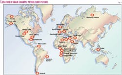
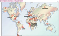
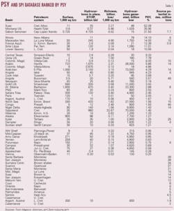
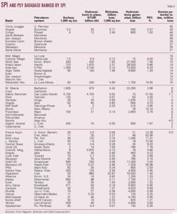
Several referenced examples of PSY have been extracted from Magoon and Klemme data and TotalFinaElf internal data bases. They are compared and exploited in Tables 1 and 2 and, in part two of this article, in Figs. 2, 3, and 4. The cases cited in this article are reported in the location map of Fig. 1.
Next: How the petroleum system relates to the petroleum province.


