South Africa's east coast frontier offers untested mid to deepwater potential
This article highlights the results of a recent reappraisal of the petroleum geology of the South African offshore Cretaceous Durban and Zululand basins.
The basins are located at the southern end of the Mozambique basin, which hosts giant Temane and Pande gas fields. Exploration the past 30 years has focused on a nearshore trend of structural closures and has involved the drilling of only four wells northeast of Durban, but this approach has proved disappointing.
However, a critical review of the regional geology and the drilling results has now provided compelling evidence of large untested structural and stratigraphic traps and confirmation of overlooked traces of oil in the most recently drilled well Jc-D1, drilled in 2000. The 39,000 sq km late Cretaceous Tugela cone, covered by limited seismic data, is also shown to host prospective features.
The purpose of this article is to draw attention to the little-explored frontier basins that have the advantage of proximity to the Durban, Tugela Valley, and Richards Bay industrial markets. This enhances the possibility of a commercial development in the event of an offshore discovery.
Basin evolution
The onshore Zululand basin is flanked to the west by the Lebombo mountain range, which comprises a 6,000-m thick mid-Jurassic basalt and rhyolite volcanic succession (184-178 Ma). The mountain range dips steeply to the east, where the volcanics underlie the sedimentary succession.
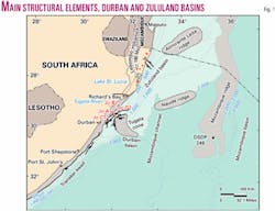
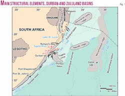
The southern boundary of the Zululand basin is arbitrarily delineated by 28° 50´ S. Lat., at which point the onshore Lebombo volcanic succession is displaced offshore by faulting1 (Fig. 1). The review of the evolution of the Mozambique basin by Matthews2 is applicable with little qualification to the South African Zululand basin, which is separated from it only by politics, not geology.
A major new insight provided by these authors is the proposal that "proto-oceanic crust" forms the basement beneath the Mozambique basin. In this model, the outcropping 180 Ma basalt and rhyolite succession which forms the Lebombo mountain range is considered by Matthews2 to possibly represent the onshore expression of seaward dipping reflectors (SDRs) and to constitute the terrain beneath the offshore Zululand and Durban basins.
The southern limit of the 4,000 sq km Durban basin (Fig. 1) is determined by the edge of the continental plate (at 30° 50´ S. Lat.), which marks the line of separation of the Falkland plate.3 This line also represents the northern margin of the Natal valley.
The Durban basin is structurally more complex than the Zululand basin, as it has been affected by the Falklands/Agulhas transform fault.
Both basins initially developed during the Jurassic to Early Cretaceous breakup of the Gondwana supercontinent. The development of the basins has been constrained by tectonic structures formed during the rift and drift phases of the Gondwana breakup. Normal faults typical of an extensional regime as well as later right lateral strike-slip faulting influenced basement geometry. The basin development is described in more detail below.
Late Jurassic (+160 Ma)
The Mid to Late Jurassic was characterized by the separation of East and West Gondwana. Upward tilting and flexing of the eastern side of West Gondwana (Natal, Mozambique, and the Falkland Plateau) accompanied the separation.1
Plate tectonic reconstructions1 suggest that early divergent plate movements between East and West Gondwana resulted in transtensional stress, which initiated the development of rift basins along the breakup margin. Igneous activity accompanied crustal extension and rifting.
Early Cretaceous, Valanginian (+126 Ma)
The movement of the Maurice Ewing Bank (Falklands microplate) from its original position south of the Durban basin, dominated the tectonic processes of the Early Cretaceous.
The present day southern Natal Valley may, in fact, represent the scar of the westward-drifting Falklands microplate.3 Right lateral strike-slip faulting influenced segments of the breakup margin and both divergent and transtensional movement, served to extend the continental crust and form north-south trending horst and graben structures.
The Valanginian thus marked the onset of drift and dominant sedimentary processes included the deposition of terrigenous and marine sediments.3 A large seaward-dipping fault is interpreted to have formed in response to thermal subsidence after drift.4
Aptian (+110 Ma)
During the Aptian, the Falkland microplate cleared the southern tip of Africa.4 At this stage, the Durban and Zululand basins are postulated to have experienced deposition of organic shales associated with the worldwide anoxic event. Sediment deposition was also associated with the proto-Tugela Delta.
Cenomanian (+92 Ma)
Sediment loading during the Cenomanian reactivated the major thermal subsidence fault, which initiated during drifting. The depositional regime of the Tugela delta and submarine fan system was well established by the mid-Cretaceous.5
Tertiary
The Tertiary tectonics were characterized by two periods of uplift.
The first was the Oligocene uplift of the African craton and the accompanying marine regression. Sedimentary processes include marine and deltaic deposition in the Durban basin.
The second event was the Neogene uplift of the shelf area accompanied by the deposition of modern Tugela River sediments.
The Tugela Delta
The Tugela and other river systems have played a major role in shaping the landscape of eastern South Africa.
The course of the lower Tugela River is controlled by east-west faults developed in Precambrian basement. In the Late Cretaceous to Tertiary, the Tugela River was a major source of sediments, which built up the extensive sediment pile of the Tugela cone. The cone is a large constructional delta that extends out across the shelf margin to about 3,000 m of water and beyond.
According to Dingle,6 the Natal Coast discharge would have been substantial, following elevation of the hinterland in mid-Cretaceous times. Seismic evidence suggests that two sediment growth phases are present, one related to synrift and early drift sediment supply and the other to a renewal of progradation in the younger Tertiary. Northwest to southeast trending seismic lines (dip sections) show prograding Tertiary beds with oblique seismic signatures.
Drilling has intersected prodelta shales comprising upward coarsening regressive cycles. The deltaic signature is particularly well displayed in the Tertiary succession.
The prospectivity associated with the Tugela delta remains untested. However, upper slope channels, basin floor fan systems, and stacked structural closures, which fall within the oil window, make prospective exploration targets within the delta. Within the basin, numerous interpreted gas escape features are imaged on seismic data and are associated with possible chemotrophic mounds on the sea floor (Fig. 2).
Durban basin petroleum elements
Only four wells have tested Durban basin hydrocarbon potential.
All four wells were drilled on shelf margin highs to intersect synrift sediments draped over older economic basement. In hindsight they were not optimally positioned, being located at the shelf edge in what has since been interpreted as sand bypass zones.
Soekor (Pty.) Ltd. drilled wells Jc-A1, Jc-B1, and Jc-C1. After drilling Jc-D1, Phillips Petroleum Co. relinquished the acreage. From subsequent work, it is clear that none of the four wells tested a trap that demonstrated structural closure.
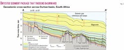
A large sediment thickness of the Early Cretaceous basin-fill remains untested, basinward of the drilled area. The total thickness of the Jurassic-Cretaceous sequences in the northern Durban basin is more than 4,000 m. In the Tertiary, the depocenter shifted slightly to its current location off Durban where around 2,000 m has been mapped, with deltaic features forming local thicknesses (notably the Tugela cone).
Jc-A1 intersected 1,300 m of Tertiary sediments. The accumulation of sediments in this area reaches a total of 5,800 m.7 This sediment package thickens basinward (Fig. 3).
Reservoir potential
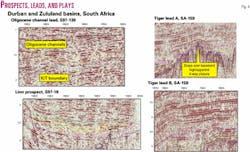
With the wells positioned on shelf margin highs, none encountered sandstones of significant thickness. Seismic evidence suggests that reservoir rocks are likely to be associated with basin floor fans, turbidites, channel systems, and stacked structural closures8 (Fig. 4).
The present-day surface geology of the Natal interior and the Tugela river catchment area is dominated by outcrops of the Natal Group sandstones and igneous basement. This implies that from the start of rifting, the entire Karoo Supergroup, including sand-rich lithologies of the successive Molteno, Clarens, and Elliot formations, has been eroded, providing good sand-rich provenance for the offshore reservoir rocks within the Durban and Zululand basins.
Source rocks
To date, only gas-prone source rocks have been encountered during drilling.
It is prognosed on the basis of the basin formation model that oil-prone source rocks could be developed downdip from the drilled positions.
Encouragement for the existence of source rocks deeper in the basin is provided in the form of organic enrichment in the Hauterivian to Aptian succession in Jc-B1 and Jc-C1, and minor gas shows recorded in Jc-B1 in the pre-Barremian.
The early Cretaceous was characterized by the movement of the Maurice Ewing Bank (Falklands microplate) from its original position adjacent to the Durban basin. Deepsea Drilling Project holes 330 and 511, located on the Maurice Ewing Bank, intersected thick, oil-prone source rocks of Kimmeridgian to Aptian age.9 Identical source rocks are postulated to occur within the Durban basin in the rift and early drift succession, which underlies the Tugela cone.
Jc-D1, although classified as a dry well, has provided the first evidence of a predicted petroleum system. Analyses conducted after the well was drilled reveal the following:
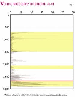
Jc-D1 mud gas values indicate a trend of increasing wetness index [(C5/Â(C1 to C5)] with depth. Positive anomalies within this maturity curve correspond with thin sandstone units. At the base, the wetness index exceeds 25% (Fig. 5).
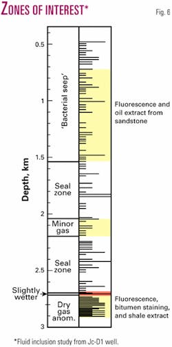
In addition, fluid inclusion studies of Jc-D1 samples reflected bacterial sulfate reduction in the presence of seeping light hydrocarbons within the Oligocene interval. Fluorescence was also observed, and an extract at this interval yielded lightly biodegraded oil.
The basal section of the well is characterized by bitumen staining and fluorescence. Extract analysis, conducted by GeoMark, yielded light oil from this interval. Interpretation of the results suggests that the source rock is a distal marine claystone of Kimmeridgian age8 (Fig. 6).
Based on the above evidence, source rocks are predicted to occur within the Jurassic grabens, the Barremian to Aptian, and the Cenomanian to Turonian sediments of the Durban and Zululand basins.
Play types
Large four-way dip closed structures and stratigraphic traps occur within the basins.
Upper slope channels, basin floor fan lobes, and stacked structural closures constitute the principal exploration targets of the Tugela Delta as grouped below. These plays are clearly evident on seismic sections and are supported by existing well and outcrop data (Fig. 4).
- Upper Cretaceous.
- Large four-way dip closed anticlines at breakup unconformity level.
- Distal turbidite slope fan reservoirs.
- Turbidite sands over basement features.
- Cenomanian-Turonian.
- Distal turbidite slope fan reservoirs.
- Basin floor fan complexes.
- Channel sands.
Status of basins
The Durban and Zululand basins are large, unexplored territories which have been evaluated by only 18,400 km of 2D seismic data (mostly 1976 vintage) and four offshore wells. For the first time this area now demonstrates evidence for a petroleum system.
Additional seismic data are essential and will allow for better definition of leads and an enhanced understanding of the petroleum geology. However sufficient encouragement for the presence of reservoirs, traps, source rocks, and active petroleum systems makes further exploration of the Durban and Zululand basins imperative.
References
- Kitchin, K.A., and McLachlan, I., "Tectonics and Hydrocarbon Potential of the East Coast of South Africa," unpub. Soekor report, 1996, 49 p.
- Matthews, A., Lawrence, S.R., Mamad, A.V., and Fortes, G., "Mozambique basin may have bright future under new geological interpretations," OGJ, July 2, 2001, pp. 70-75.
- Hartnady, C.J.H., Ben-Avraham, Z., and Rogers, J., "Deep-ocean basins and submarine rises off the continental margin of southeastern Africa: new geological research," South African Journal of Science, Vol. 88, 1992, pp. 534-539.
- Ben-Avraham, Z., Hartnady, C.J.H., and Malan, J.A., "Early tectonic extension between the Agulhas Bank and the Falkland Plateau due to rotation of the Lafonia microplate," Earth Planet. Sci. Lett., Vol. 117, 1993, pp. 43-58.
- Goodlad, S.W., "Tectonic and sedimentary history of the Mid-Natal Valley (SW Indian Ocean," Joint Geological Survey/University of Cape Town, Marine Geoscience Unit, Bull. 14, 1986, 415 p.
- Dingle, R.V., and Scrutton, R.A., "Continental breakup and the development of post-Paleozoic sedimentary basins around Southern Africa," GSA Bull., Vol. 85, 1974, pp. 1,467-74.
- Dingle, R.V., Siesser, W.G., and Newton, A.R., "Mesozoic Tertiary geology of South Africa," A.A. Balkema/Rotterdam, 1983, 375 p.
- Singh, V., "South Africa: The unpicked fruits of the Durban and Zululand basins," AAPG, Cairo, 2002, p. 236.
- Comer, J.B., and Littlejohn, R., "Content, composition and thermal history of organic matter in Mesozoic sediments, Falkland Plateau," initial reports of the Deepsea Drilling Project, Vol. 36, 1976, 366 p.
The authors
Varsha Singh ([email protected]) is senior geologist with Petroleum Agency SA, where she has been employed since 1999. She is area specialist for South African east coast basins. She has a BSc (Hons.) from the University of Durban-Westville.
Ian McLachlan is concessions manager at Petroleum Agency SA. He has more than 30 years of experience in the oil industry, with special emphasis on South African paleontology. He is an author and editor of numerous publications.
