Wildlife resources and vulnerabilities summarized for 1002 Area of ANWR

ALASKA'S ANWR—3
If petroleum represents one resource abundant in the 1002 Area of ANWR, wildlife certainly comprises another.
More than 35 species of land and marine mammals, as well as over 100 species of birds, have been identified in its borders. It is used as a calving ground for caribou, a denning area for polar bears, a year-round habitat for muskoxen, and a major migration route for several kinds of waterfowl. While none of these animals is listed as endangered, some have undergone cycles of increase and decline in recent decades, posing the question of their vulnerability to changes in habitat.
Biological diversity in the 1002 Area and adjacent waters is considered very high, ecologically intact to a large degree, and valuable as a scientific resource. Much opportunity remains to advance understanding of caribou, polar bear, and muskoxen, for example.
Scientific study of ANWR wildlife has an extensive history. Early field work in the 1940s and 50s was used to argue for and support the founding of the Alaska National Wildlife Range in 1960. More thorough research began with passage of ANILCA in 1980, requiring systematic investigation of fish, wildlife, and habitat in the 1002 Area.
Since submission to Congress of the resulting report,1 work has continued, much of it focused on species deemed to be potentially vulnerable to petroleum development, e.g., caribou and muskox. Scientists from a variety of organizations,2 both in the US and Canada, have contributed to this valuable effort.
Data from these investigations have been recently combined and reviewed by Douglas et al.3 and the National Academy of Sciences.4 While Douglas et al. focus specifically on wildlife in the 1002 Area, the NAS report is more broadly based, concerned with environmental impacts across the entire North Slope, and thus provides much needed context.
What follows in the third part of this four-part series is an interpretive summary of major points from these studies and their general implications.
Land cover and habitat
The 1002 Area extends from the Beaufort Sea on the north to the foothills of the Brooks Range on the south. Flat coastal plain becomes gently rolling hill topography southward, and then slightly more rugged foothill terrain. Many north-flowing streams traverse the area, creating fairly abundant riparian settings. Tundra-type vegetation dominates, including a ground cover of dwarf shrubs, sedges, small herbs, and mosses.
Compared with areas to the west, such as Prudhoe Bay, the 1002 Area has a very narrow coastal plain, due to convergence of the Brooks Range with the Arctic Ocean.
Climate is typified by long, cold winters and short, cool summers. Precipitation is mainly light snow in winter and drizzle in summer. Subzero conditions persist from September to late May. During June and July, when temperatures warm to 40-60° F., much of the coastal plain resembles a wetland and plays host to calving caribou (Rangifer tarandus) as well as prolific mosquitoes (Cuculidae).
Green biomass (good quality forage) emerges in June. Most animal species, in their fertility and birth cycles, are closely adapted to seasonal cues; abnormally long winters are known to have detrimental effects on some populations.
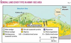
Land in the 1002 Area can be divided into four main terrain types (Fig. 1):
1. Flat coastal plains, typified by wet-moist faminoid tundra (sedge).
2. River floodplains, with diverse communities of low-growing plants (riparian).
3. Hilly coastal plain, with tussock and graminoid-herbaceous tundra.
4. Alpine habitat of the Brooks Range foothills, which support low shrubs. Green biomass used as forage by mammals is especially concentrated in the first three of these terrain types.
Caribou
Barren-ground caribou (Rangifer tarandus granti) represent the species of greatest concern regarding the possible effects of oil/gas development in the 1002 Area.
Concern is high because of the combination of scientific, cultural, emotional, and symbolic investments attached to this species. Biological data are inconclusive, and even partly conflicting, as to effects of development thus far in the Prudhoe Bay area.
Meanwhile, caribou are a crucial source of nutrition and culture for the Gwitch'in native peoples, who inhabit villages along the southern part of ANWR and in adjacent Canadian territory. Caribou are also an object of widespread public interest, due to their "exotic" character and their use as a symbol of North Slope ecosystems and untrammeled nature in general.
What are the basic facts regarding caribou presence in the 1002 Area and their possible vulnerability to development? First, it should be noted that four separate caribou herds exist in Alaska, two of which utilize the eastern North Slope: the Central Arctic Herd (CAH; present population = 31,850, up from 27,130 in 2000) and, more especially, the Porcupine Caribou Herd (PCH; population = 123,000).
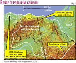
The range of the CAH lies mainly to the west of ANWR and includes most of the developed area of Prudhoe Bay and environs. The PCH has a range that spans nearly the whole of ANWR, plus large areas to the south and to the east in the Yukon Territory of Canada (Fig. 2). Both herds have their primary calving grounds on the coastal plain.
The CAH has calved mainly between Prudhoe Bay and the 1002 Area—it is therefore an important "test case" for the effects of oil field development (Fig. 2). The PCH has its calving grounds mainly in the deformed portion of the 1002 Area and adjacent Canada.
The PCH winters in the southern Brooks Range and areas to the east. Beginning in April, the herd migrates north and west, reaching the foothills and coastal plain by late May-early June. Calving normally takes place during the first two weeks of June. By late August, the herd begins to disperse south and east and commences its southward winter migration.
Nutrition needs are maximal for pregnant females in early June to early July, during calving and peak lactation. Insect harassment, mainly by mosquitoes, also occurs in mid-June and July and forces caribou to move off the lower portions of the coastal plain.
Foraging needs are met in the 1002 Area by selective feeding on highly digestible, nutrient-rich flora. To the east, in the Canadian portion of the coastal plain, calving diet has consisted of less digestible mosses and evergreen shrubs. However, calf survival appears most strongly correlated with abundance—not necessarily quality—of forage available to females during peak lactation (mid-late June).
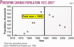
Fig. 3 shows post-calving population of the PCH during the years 1972-2001 and also relative post-calving population for all four Alaska barren-ground caribou herds. The Porcupine herd increased in size steadily until 1989 yet has since been the only population to sustain a continual decline. All other herds grew rapidly into the mid-late 1990s and have undergone only temporary declines.
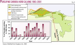
Reasons for the low growth and decrease of the PCH are not well understood. Research indicates no significant change over time in either the birth rate or calf survival rate. Fig. 4 gives aggregated calving distributions (based on observation of radio-collared females) for the period 1983-2001; data for individual years suggest no obvious patterns that correlate with herd size change.
The small inset, showing percent of females that calved in the 1002 Area, shows an overall increased use of this nutrient-rich area during the period of decline. Herd decrease thus appears a result of mortality sustained outside the calving grounds, possibly due to predation.
Major predators of caribou include grizzly bears (Ursus arctos), wolves (Canus lupus), and golden eagles (Aquila chrysaetos), with bears posing by far the highest predation risk. Such risk is concentrated in the foothills and mountains, the common range for bears, and is lowest on the coastal plain. Actual data on caribou kills by bears, however, are lacking at present.
Several factors argue for particular sensitivity of the PCH to development in the 1002 Area. These include:
1. Continual decline in herd size (apparent low capacity for growth).
2. Lack of good quality alternate calving habitat (coastal plain is narrow in this area).
3. The likelihood that females will avoid development areas during calving and peak lactation times and be displaced to areas where forage may be less abundant.
The last factor is based on observed behavior of CAH females. That portion of the CAH herd that has chosen to calve where development exists, in the Prudhoe Bay-Milne Point-Kuparuk River area, tended to be displaced 7-8 km from infrastructure and exhibited reduced parturition (fewer calves per female).
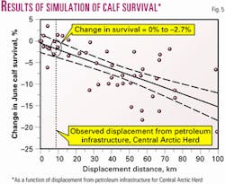
To gain some estimate of how such displacement might affect herd dynamics, a stochastic model incorporating calf survival rates, forage abundance, and displacement distance of concentrated calving areas, was used to generate the graph of Fig. 5. The simulation, considered to be conservative in its assumptions, indicated that a 4.6% reduction in calf survival would result in zero herd growth in the best of conditions. This level of reduction corresponds to a displacement of 27 km (Fig. 5), roughly three times the observed displacement for the CAH.
In the end, therefore, biological research to date remains equivocal about the potential effects of petroleum development to the PCH in the 1002 Area. Observation and modeling suggest a fairly high level of vulnerability.
However, the only existing "test case," the Central Arctic Herd, is not necessarily a good ecological analog for the Porcupine herd, as the CAH has available to it a much greater total area of coastal plain (forage areas) and has also undergone a six-fold increase during the past 2 decades. Data available at present suggest that although development may inpact individual CAH caribou and may displace females and calves away from infrastructure, actual herd-level effects of a detrimental nature appear lacking. Moreover, becaue all barren-ground herds have exhibited characteristics and dramatic changes in population, differentiating natural and human influences is a difficult and uncertain task. All factors considered, it appears possible that with proper management development in the 1002 Area, especially at a reduced level, can be compatible with caribou vitality.
Muskoxen
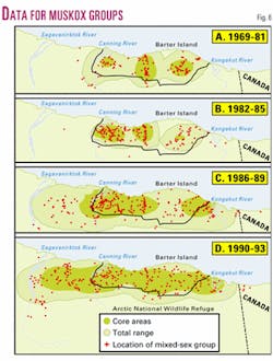
Exterminated from the North Slope before 1900, muskoxen (Ovibos moschatus) were re-introduced in 1969-70 and have since established a number of successful, low-density herds. In the 1002 Area, the population peaked in 1986 at 386 individuals and has since undergone two apparent "cycles" of decline and increase, with total numbers falling overall to 168 in 2001. At least part of this decrease is related to expansion of the total range and areas of core use beyond the limits of the 1002 Area (Fig. 6).
Muskoxen are year-round inhabitants of the coastal plain and exhibit energy-conserving activity in all seasons. Study of their behavior based on radio-collaring shows that they prefer riparian cover, particularly along river corridors where snow cover is less, and that they have a high fidelity to specific areas, especially in winter.
Seasonal strategies include higher energy intake and weight gain during the summer and reduced activity and use of low-quality forage in winter. In contrast to caribou, who give birth in June when high-quality forage is available, muskoxen females calve in April and early May.
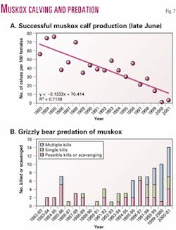
Successful reproduction depends on good body condition of females, who must have reserves sufficient to support lactation. Research indicates an overall decline in calf production during the past 20 years, reaching a minimum in 2000 and 2001 (Fig. 7A), when snow melt was especially late.
Two factors appear important in muskoxen population dynamics.
The first is predation—kills by grizzly bears and by hunters. Fig. 7B indicates a strong increase in single and multiple kills by bears from 1992 to 2001. Legal hunting in the 1002 Area, which began in 1982, has also increased, from an average of 7 individuals per year killed in 1985-89 to 10 in 1995-99.
The second controlling factor is length of the winter season. An extended cold season, causing delay in the emergence of high-quality forage needed by lactating females, may well have been partly responsible for the very low calf survival rates observed in 2000 and 2001 (Fig. 7A). Such conditions, in turn, may have increased bear predation, both by general weakening of muskoxen body condition and by decreasing other sources of food for bears.
Regarding muskox vulnerability, several points should be made. As year-round inhabitants of the 1002 Area, muskoxen appear particularly vulnerable to disturbance in selected foraging areas. Animals remain loyal to small, restricted areas in winter, especially along drainages; changes that would displace them away from such areas (e.g., withdrawal of gravel) have the potential for detrimental effects.
It should be noted, however, that muskoxen have expanded both their total range and core use areas westward to the Sagavanirktok River, where the Trans-Alaska Pipeline and Dalton Highway exist. Response of these animals to noise of seismic exploration has been found to vary from one herd to the next, possibly due to levels of experience: Some herds seem undisturbed at less than 1,000 ft, while others show signs of disturbance at nearly 2 miles away. Minimizing impacts would likely require industry to avoid, as much as possible, locating permanent facilities along specific river corridors frequented by muskoxen.
Polar bears
Polar bears (Ursus maritimus) in the Beaufort Sea region have a very large total range extending for hundreds of miles offshore (Fig. 8). Most of the year these animals spend on pack ice, with some females migrating south to den along the coastal plain. In spring and summer (May-August), bears move north, then south again in October, with total annual movement ranging from 909 miles to over 3,877 miles.
Detailed analysis has identified three, overlapping populations. Of these, the Southern Beaufort Sea population inhabits the coastal portion of northeastern Alaska and adjacent Canada for part of the year. This population has grown at a rate of over 3% per year between 1968 and 1998 and may now number 2,500. Such growth has occurred during the entire period of petroleum development along the North Slope. Mortality, particularly among female bears, appears overwhelmingly (85%) a result of hunting by humans. Other causes of natural death among adults are not well understood at present.
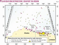
Cub survival does not differ for individuals born in dens on land (e.g., the 1002 Area) or on pack ice. Over time, there has been a tendency for females to den in more southerly areas, including the North Slope between Barrow and the Canadian border (Fig. 8). This may be a combined result of population growth, food source distribution, and climatic factors.
Some evidence suggests that there has been a decrease over time in the total use of the 1002 Area for denning. Yet this area retains a larger concentration of dens than adjacent portions of the North Slope (Fig. 8).
Data collected to this point suggest that polar bears are resilient to many forms of disturbance.
During the past 2 decades, these animals have been subjected to a variety of activities of human origin, including hunting, shipping, road building, seismic surveying, industrial noise, and petroleum development. Yet none of this seems to have affected cub production or population growth.
Such factors as relatively high activity level, large-scale movement, and construction of dens insulated from external effects may all play a role in the ability of these animals to resist disruption. The dominant vulnerability for polar bears is related to offshore oil spills, especially as they might affect pack ice areas.
Snow geese
A significant portion of the eastern (deformed) 1002 Area is used by lesser snow geese (Chen caeruluscens caerulescens) as an autumn staging area (Fig. 9).
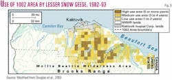
These geese are part of the Western Canadian Arctic population, which has grown from approximately 200,000 (200K) in the mid-1980s to 500K today. Use of the 1002 Area occurs for 2-4 weeks in late August-mid September and includes intensive feeding to increase fat reserves for migration, whose next leg consists of a 1,300-mile nonstop journey to northern Alberta.
During a 10-year observation period, the actual numbers of snow geese estimated to stage on ANWR varied considerably, from 12.8K in 1983 to over 309K in 1985 (Fig. 9, inset). Such variation reflects the tendency in some years for a majority of the population to remain in Canada: Fig. 8 (inset) indicates that this was the case, in fact, for most of the surveyed period. Reasons for this tendency appear related to annual habitat conditions, which have included poorer forage availability and the presence of early snow cover either in Canada or the 1002 Area.
Snow geese feed primarily on the stembase of tall cottongrass (Eriophorum angustifolium) and shoots of the northern scouring-rush (Equisetum variegatum). In particular, they eat the underground, regenerating portion of cottongrass, which experimental evidence suggests will need 4 years to re-grow only 50% of its original mass. Feeding therefore reduces the nutritional suitability of any particular area in later years, providing, again, one important reason why Western Arctic geese employ a very large staging area and exhibit much annual variety in use of the 1002 Area.
Research has also shown that snow geese are easily disturbed by noise-producing activity, such as aircraft. Flocks were observed to flush at a mean distance of 3.25 miles from helicopters, and were displaced an average of 1.1 miles.
Repeated disruption of feeding activity causes fewer animals to use the originally selected area in subsequent days. This has the potential effect of lowering overall forage intake during normal staging, thus reducing fat reserves and either requiring extended feeding time or reduced survival capability.
Such effects would be greatest on juvenile snow geese, who spend a larger percentage of each day feeding compared with adults, build fat reserves at a slower rate, and begin long-distance migration with small reserves. Restricting or avoiding industrial activity (including air traffic) during the brief annual staging period would help minimize any impacts from petroleum exploration and production.
Other species
Bowhead whales migrate between the Bering Sea and the Canadian portion of the Beaufort Sea. Migration takes place in spring and fall, with animals passing offshore the 1002 Area sometime in late May-early June and late August-September.
These whales are a primary source of food and cultural sustenance to the native Inupiat people of the North Slope, including those who live in Kaktovik. The number of whales has grown significantly (3.2%/year, from 1978 to 1993), to an estimated 8,200 individuals at present.
Such growth has taken place throughout the period of petroleum development. However, it is well-documented that bowhead whales avoid noise-producing industrial activity. For example, observations associated with drilling in the Hammerhead and Kuvlum offshore areas (for location, see OGJ, Apr. 21, 2003, p. 36, Fig. 2), as well as marine seismic surveying, document that whales divert 9-15 miles around noise sources. These animals are also deemed highly vulnerable to death or damage from spilled oil.
Other species of possible concern include arctic fox, seals, grizzly bear, a variety of birds (loons, shorebirds, tundra swan, black brandt), and fish. All of these animals have been observed and, to varying degrees, studied near existing facilities at Prudhoe Bay oil field.
To date, based on information covered in the National Academy report, none appears to have suffered long-term damaging cumulative effects. The main reason for this seems to be a combination of adaptation on the part of the animals and "learned behavior" by humans, e.g., improved design of facilities, often under regulatory demand, to minimize impacts.
Much has been learned from the interaction between wildlife and development at Prudhoe Bay. The circumstance of this interaction has presented unique opportunities for study. The state of knowledge at present, while far from satisfactory, nonetheless has come a long way.
Overall, to the unbiased observer, it points to some important local problems (small oil and chemical spills, inadequate disposal of garbage, disruption of local drainage patterns), yet also to a lack of general ecological degradation.
Key points
Current understanding related to wildlife in northeastern Alaska and adjacent Canada suggests several important points:
1. Significant vulnerability exists for several species—caribou, muskoxen, snow geese, in particular—to undergo decline as a result of unregulated, all-season oil-gas development in the 1002 Area. Such vulnerability can be greatly reduced, but not erased, if industrial activity is restricted to periods of minimal use by wildlife (winter) and is concentrated away from specific sites of favored use.
2. In general, onshore vulnerability is elevated for—and in some cases, confined to—the eastern, deformed portion, where oil prospectivity is lower yet where use by animals is higher.
3. Experience at Prudhoe Bay suggests that onshore vulnerability mainly results from the potential for petroleum infrastructure to displace animals away from important foraging areas. Abundance and availability of food appear to be paramount considerations.
4. All marine species, as well as polar bears, are seriously vulnerable to the effects of a large oil spill. To date, no such spill has occurred in the Beaufort Sea. Development activity in marine waters, however, has been limited thus far and may expand significantly in the future.
5. Development at Prudhoe Bay has not brought ecological devastation. A number of species—including caribou, polar bear, bowhead whale, snow geese, and arctic fox—have been able to increase their populations significantly during the last 3 decades, since hydrocarbon exploration and production began.
This last consideration does not obviate the potential for adverse effects from future development. However, it does suggest that wildlife in the 1002 Area is characterized not only by abundance and diversity, but also by a certain vitality—or, at the very least, a mixture of fragility and resilience.
Certainly, the ultimate dynamism of the coastal plain ecosystem in the face of development cannot yet be known. As implied presciently by the National Academy study, the greatest long-term vulnerability may well be related to climate change, which could affect food sources on the largest scale, but whose mitigation obviously lies beyond the scale of issues related to North Slope development alone. F
References
1. Clough, N.K., Patton, P.C., and Christiansen, A.C., eds., "Arctic National Wildlife Refuge, Alaska, coastal plain resource assessment—Report and recommendation to the Congress of the United States and final legislative environmental impact statement," U.S. Fish & Wildlife Service, US Geological Survey, and Bureau of Land Management, Washington, DC, 1987, Vol. 1, 208 p.
2. Collaborators involved in this work have included specialists from the US Fish & Wildlife Service, Alaska Department of Fish and Game, University of Alaska, Canadian Wildlife Service, Yukon Department of Renewable Resources, Northwest Territories Department of Resources, Wildlife, and Economic Development, and the USGS biological sciences division.
3. Douglas, D.C., Reynolds, P.E., and Rhode, E.B., eds., "Arctic Refuge Coastal Plain Terrestrial Wildlife Research Summaries," US Geological Survey Biological Science Report USGS/BRD/BSR-2002-0001, 2002; available online (http://www.absc.usgs.gov/1002/).
4. National Research Council, "Cumulative Environmental Effects of Oil and Gas Activities on Alaska's North Slope, 2003; available online (http://www.nap.edu/catalog/ 10639.html?onpi_topnews_030403).
Scott L. Montgomery
Consultant and writer
Seattle