Lusitanian basin highlights important potential in Portugal
Exploration activity the past 5 years has done much to heighten the petroleum potential of Portugal's Lusitanian basin. A new, subsalt petroleum system involving Triassic synrift sandstone reservoirs has been documented, significant volumes of gas in place have been confirmed in a 700-m column of fractured and vuggy Jurassic limestones, and Upper Jurassic reefs analogous to recent discoveries in the offshore of Eastern Canada have been delineated.
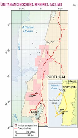
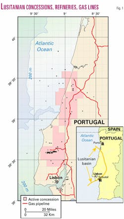
The Lusitanian basin is located on and off west-central Portugal. It is limited on the east by the Iberian Meseta and extends from south of Lisbon north to about Porto (Fig. 1). The basin has undergone sporadic drilling episodes since 1906, the most recent being a four-well campaign by Mohave Oil & Gas Corp. in 1998-2001.
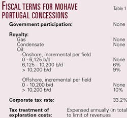
Around 100 exploratory wells have been drilled in the basin, of which 80% had oil and gas shows while drilling and 27% recovered live oil or gas at surface.1 2 Shows were reported from Triassic, Jurassic, and Cretaceous strata. Hydrocarbon potential in the basin is significant, yet Portugal produces no hydrocarbons. Consequently, Portugal offers the best hydrocarbon royalty and tax incentives in the European Union (Table 1).
Portugal currently imports all oil and gas used in the country. Oil is delivered to refineries located in Porto and Setúbal, which have a combined capacity of 250,000 b/d. The Maghreb-Europe gas pipeline from Algeria to Spain and then into Portugal provides 1 bcfd to the Iberian Peninsula.
A recent report by BP3 estimated gas consumption will double in Spain in the next few years. Mohave expects similar rapid growth in Portugal based on in-country discussions with energy sector entities.
The main gas distribution trunkline for Portugal traverses the Lusitanian basin north-south (Fig. 1). The Portuguese pipe- line's capacity is 450 MMcfd, of which about 300 MMcfd is currently utilized. Capacity can be expanded with addition of compressors.
Lusitanian geology
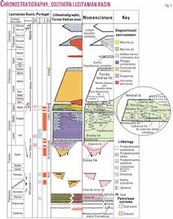
Chronostratigraphy of the Lusitanian basin is illustrated in Fig. 2. The Lusitanian basin initiated as a Late Triassic rift basin filled with synrift siliciclastics and capped by post-rift evaporites.
After open marine conditions became established in the post-rift basin, the area developed into a carbonate shelf during the Jurassic. It was overwhelmed by westward-prograding siliciclastics during latest Jurassic and Cretaceous opening of the North Atlantic. The area experienced tectonic episodes during the Middle and especially Upper Jurassic. Lastly, the basin was subjected to significant transpression during Tertiary Alpine orogenesis.
The halite-bearing Lower Jurassic Dagorda evaporite section divides the stratigraphic column into an underlying synrift clastic section and overlying post-rift carbonate shelf.
Prerift rocks consist of various Hercynian terrains of metamorphosed and sedimentary Paleozoic strata which include organic-rich Silurian black shales and Permo-Carboniferous coals. Synrift rocks are the continental siliciclastics of the Triassic Silves formation and possibly the lower part of the Dagorda formation. The post-rift section begins with the widespread Dagorda evaporites with upper and lower transitional carbonate facies, then develops into a major, west-facing carbonate shelf during the Lower and Middle Jurassic (Lias and Dogger).
Regional Coimbra dolomite marks the base of the carbonate pile and is overlain by low-energy, quiet water limestones of the Brenha formation. The argillaceous lower part of the Brenha is a well-documented oil source rock with recorded TOC content up to 18%. Nearshore and high-energy carbonate grainstone and reef facies equivalents of the Brenha are termed the Candieiros formation.
These two formations comprise most of the Lower and Middle Jurassic section. Geologic evidence indicates that significant tectonic activity began during the Middle Jurassic, and a major unconformity marks the top of the sequence.
The carbonate shelf was re-established during the Upper Jurassic (Malm) and tectonic activity continued, leading to the development of numerous Upper Jurassic subbasins which often had distinct depositional histories.
The Montejunto formation is the basal Upper Jurassic carbonate unit. It exhibits well-developed grainstones and reef facies on local highs and along the tectonic sills between subbasins. Locally, the lower part of the Montejunto (Oxfordian) is an organic-rich limestone capped by anhydrite which is termed the Cabaços formation. The Cabaços organic-rich facies is a documented source rock with TOC values up to 3%.
By Kimmeridgian time, siliciclastics derived from the Meseta highlands to the east dominate the depositional system. The primary marine facies of this clastic wedge is the Abadia formation, largely composed of shale, marl, and siltstone, with some fine-grained sandstones. This unit also contains documented source rock facies. It is overlain by westward prograding continental clastics of the Grés Superiores formation. A well-developed Upper Jurassic fan-delta complex developed in the Arruda subbasin. The Upper Jurassic section is also capped by a major unconformity.
Continental clastics of the Torres Vedras formation prograde westward across the Late Jurassic unconformity surface. Local seals are probable within this continental sequence, but no regional seals have been recognized in the Cretaceous and younger section, which is not discussed further.
Miocene Alpine orogenesis left a significant tectonic overprint on the basin. Many major faults that were active during rifting and Jurassic tectonism were reactivated as wrench faults, and many young structures without prior structural or stratigraphic history were developed.
Subsalt petroleum system
The subsalt petroleum system consists of Paleozoic source rocks and synrift Triassic sandstone reservoirs sealed by Dagorda evaporites.
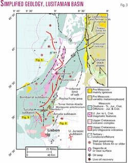
Mohave and others have sampled Silurian, graptolitic black shales, analogous to North African Silurian source rocks, along the Lusitanian basin margin (Fig. 3). TOC values up to 9% and equivalent %Ro values as low as 1.04 have been obtained from these samples, indicating these rocks retained significant generative potential prior to subsidence and reburial beneath the Lusitanian basin.
Extracts of oil stains found in basal Dagorda transitional dolomites beneath 2,000 m of Dagorda evaporites and mudstones in the Mohave Aljubarrota-1 well were biomarker fingerprinted and characterized as from an early Paleozoic source rock, verifying a working subsalt petroleum system.
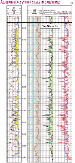
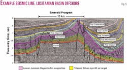
The Mohave Aljubarrota-2 well drilled 589 m of synrift Silves formation clastics with oil and gas shows without reaching the prerift section (Fig. 4). Emerald Prospect (Fig. 5) is an example of an offshore subsalt horst block targeting gas reserves of 1 to 4 tcf in the Silves formation.
Suprasalt petroleum systems
The oldest suprasalt source rock is the oil-prone, argillaceous Lower Brenha formation. Reservoirs include underlying Coimbra dolomite and upper Dagorda transitional carbonates, overlying Candieiros oolitic and bioclastic grainstones, and fractured Brenha carbonates. Seals are tight and-or marly carbonates of the Brenha and overlying basal Upper Jurassic.
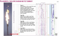
The Aljubarrota-2 well penetrated a 761-m column of highly fractured and vuggy gas-charged carbonates in the Lower and Middle Jurassic Brenha formation above the Dagorda evaporites (Fig. 6). This column is bounded by seismically mapable horizons, the SB-1 and SB-2 Markers.
An open hole DST at the base of the gas column flowed gas at rates between 1 and 2 MMcfd for 7 hr before being killed by water influx (Fig. 7). Casing was set, and the zone was further tested after the well reached TD in the Triassic Silves formation.
One test from a net 43 m of perforations through cemented casing (and damaged formation) produced water-free gas at about 350 Mcfd.
A second test was performed by perforating the base of an 800-m section of casing purposely left uncemented (Fig. 7). This uncemented interval covered the upper half of the interpreted gas column and an additional 400 m above its top.
Upon perforating, the well immediately flowed gassy water to surface, but unrecognized water zones in the upper part of the uncemented interval (above the top seal at the SB-1 Marker) overwhelmed attempts to swab the well down and allow free gas flow to surface.
The well has been temporarily abandoned, but it and subsequent offset drilling have verified the presence of the gas column. The 761-m height of the gas column is well in excess of any structural closure mapped at the pay horizon, indicating a potential multi-tcf resource in the area.
Upper Jurassic source rocks in the Abadia formation and Cabaços formation are most important in the southern Lusitanian basin where Upper Jurassic subbasin development was most extensive. These source rocks have charged reservoirs in fractured Montejunto micrites and Montejunto reef and grainstones facies and in fine-grained sandstones of the Abadia and Grés Superiores formations.
This is evidenced by the limited, shallow (<200 m) oil production at Abadia anticline, the tar and heavy oil saturated outcrops of an exhumed oil field at Rocha Forte, and the 36° gravity oil recovered from the Benfeito-1 well (Fig. 3). Seals are tight, marly Montejunto carbonates, Cabaços anhydrite, and Abadia marl and shale.
The Torres Vedras-Abadia-Montejunto anticlinorium is a 30-km-long structural trend which lies along the tectonic sill separating the Bombarral subbasin from the Turcifal and Arruda subbasins (Fig. 3). It is the locus of abundant surface oil seeps and the significant oil-charged reservoirs noted above.
Well-developed Middle Jurassic oolitic grainstones indicate it was a regional positive trend at the end of the Middle Jurassic, and probably acted as a constriction to open marine circulation between the Bombarral and Arruda subbasins which ultimately resulted in deposition of the Cabaços anhydrite facies.
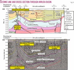
Miocene transpression related to left-lateral wrench movement on bounding fault zones resulted in thrust-breaching of the ancestral anticline and compartmentalization of the hanging wall into numerous culminations. The Abadia anticline production and Benfeito-1 oil recovery were from the hanging wall; the Rocha Forte exhumed oil field in Upper Jurassic reefal carbonates is in the exposed updip portion of the unthrusted, ancestral footwall anticline. We provide a summary of exploration plays along this thrusted anticlinal trend as well as other exploration potential in the Arruda subbasin (Fig. 8).
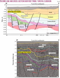
A last major facet of the petroleum potential of the Lusitanian basin is the seismic definition of a significant Upper Jurassic (Oxfordian), shelf-edge reef complex along the western margin of the Turcifal subbasin (Fig. 3). Fig. 9 shows a seismic line and corresponding cross-section across the reef tract. Fig. 10 is a "cosine of instantaneous phase" panel of that line, which clearly illustrates the reef geometries and prograding Abadia clinoforms that cover the reef sequence.
Upper Jurassic source facies with up to 6% TOC have been sampled at surface outcrops on the margins of the Turcifal subbasin. The deep, anoxic forereef environment indicated by Figs. 9 and 10 suggests these source facies are better developed along the basin axis. This reef development is age-equivalent to the Abenaki reef sequence of the Scotian shelf of eastern Canada where the recent, tcf-size Panuke Deep gas discovery was made. During the Upper Jurassic the Lusitanian basin and Scotian shelf were in the same geographical setting on opposite sides of the opening Atlantic Ocean.
Framework
Prospects are excellent for the development of hydrocarbon production in Portugal's Lusitanian basin. Multiple working petroleum systems are present, and many large untested structures remain to be drilled.
The country currently imports all crude oil and natural gas needed to supply its two refineries and burgeoning gas distribution system. Hydrocarbon reserves in the onshore and shallow water offshore Lusitanian basin could displace current import stocks with little or no lag time for development of infrastructure.
Exploration and production services are reasonably accessible from established European activity centers, and if the current Portuguese Deepwater Licensing Round, for which the bid deadline is December 2002, is successful, a new phase of exploration activity will only enhance that situation.
Production facility fabrication exists at the shipyard in Setúbal. In short, the petroleum geology, infrastructure, and regulatory climate of the Lusitanian basin combine to make it a uniquely attractive opportunity in today's exploration and production environment.
References
- Gabinete Para a Pesquisa e Exploração (GPEP), "The Petroleum Potential of Portugal," Comissão Reguladora Dos Produtos Quimicos e Farmacêuticos, Portugal, 1993.
- Archives, Instituto Geologico e Mineiro (IGM), Lisbon.
- "BP sees gas consumption doubling in Spain over coming years," AFX News, story filed Aug. 27, 2002.
The authors
Thomas L. Uphoff is chief geologist for Mohave Oil & Gas Corp., which he joined in January 1997. He has over 26 years domestic and international experience, including 14 years with Sohio/BP and 6 years with BHP Petroleum (Americas) Inc. He has worked on and directed exploration projects in the US Gulf Coast, Midcontinent, and Rockies and in Europe, Canada, Latin America, and the Middle East. He received BS and MS degrees in geology from the University of Texas at El Paso.
S.K. Hogan, operations manager for Mohave, has over 25 years' experience with numerous oil companies in the Far East, Middle East, Europe, North America, Latin America, and Africa. He earned a BS degree from the US Military Academy (West Point) in 1972.
Michael J. Stearns is vice-president-exploration for Mohave. In 1970-90, he worked at various exploration line and staff positions for Texaco, Tenneco, and Valero Production Co., focusing on the US Gulf Coast, East Coast, Rockies, and Michigan basin. In 1990, he and two associates founded Trexpro Inc. to provide exploration services to industry clients in the US and Canada. He joined Mohave in October 1993. He holds a BS in geology/geophysics from Indiana University and MBA from the University of Houston.
Patric H. Monteleone is chairman and president of Mohave, which he founded in August 1993. He has worked as an explorationist and in exploration management for British Petroleum, Sohio, Occidental, Tenneco, and Heritage Exploration and Production Co. He has extensive exploration experience on the Alaska North Slope, US Gulf Coast, Europe, and in Latin America. He received a BS in geology from Northern Arizona University and PhD in geology from Leicester University, England.
David P. Stemler is chief geophysicist for Mohave. He has worked as an interpretation geophysicist for over 25 years in domestic and international exploration and production. Before joining Mohave in June 2001 he worked for Amoco in 1977-80, Conoco 1980-99, and consulted 1999-2001. He also has extensive 2D and 3D geophysical operations experience in the Americas, Southeast Asia, Africa, the North Sea, and the Middle East.
