Integrated exploration technologies model Trenton in western New York
Over the last several years, the Ordovician Trenton-Black River has emerged as a significant reservoir in the Appalachian basin of New York and West Virginia. Because information on the reservoir has been limited and because of the relative newness of meaningful exploration success in this reservoir, the characteristics of this pay and the exploration models have only been indirectly discussed.
Direct Geochemical and Pyron Consulting decided to apply their own methodology, Integrated Exploration Technology (IET), to the development of a model for this pay. The IET methodology involves the application of a variety of geologic, geochemical, and nonseismic geophysical technologies to the evaluation and identification of hydrocarbon producing reservoirs.
The ideal exploration and development program integrates both seismic and nonseismic technologies as appropriate to the play and prospect conditions. By appropriate technologies, we mean that individual technologies are applied to answering questions they are best suited to address in such a manner as to fully integrate all sources and types of data into a coherent whole.
The emphasis in IET on nonseismic technologies is two-fold:
- The costs of the technologies are generally a small fraction of that of seismic, even when combined; and
- The technologies can be readily integrated into a whole interpretation. This makes the package very powerful as a complement to the appropriate use of seismic methods. Furthermore, it can dramatically reduce overall costs while enhancing success rates.
Thus, IET is readily used by small and medium sized independents who have little staff or technical resources, as well as by larger companies.
The technologies used in IET vary depending on the type of project, play, amount of existing data, and the budget of the operator. In lightly drilled or frontier areas, IET will involve not only geochemical and some subsurface geology, but remote sensing, fracture trace analysis, gravity, magnetics, and other nonseismic methods, both airborne and ground. An infill drilling project might focus more on subsurface geology and geochemistry. The operator can design the project to address specific needs and questions.
In a project co-funded by the New York State Energy Research and Development Authority (NYSERDA), Direct Geochemical and Pyron Consulting completed an exhaustive study of Glodes Corners Road field of Prattsburg and Pulteney Townships, Steuben County, NY.
In this study, we integrated subsurface mapping techniques, petrophysical analysis, regional gravity, remote sensing analysis, production history, and surface soil geochemistry to analyze the field. This study indicates the development of a model that can be used by industry to significantly enhance the effectiveness and economics of exploration and development of Trenton-Black River reservoirs in the Appalachian basin.
Trenton discoveries
In the mid-1990s, a large independent company drilled a series of Trenton-Black River test wells throughout south-central New York.
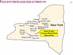
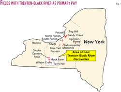
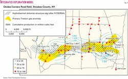
One of these wells, the Gray 21625 (API #31-1010-21592), in Pulteney Township of Steuben County, NY, was completed in 1995 and flowed 3.29 MMcfd from the pay zone. This is the Glodes Corners Road field discovery well. Subsequent drilling has extended the field east and west (Fig. 1).
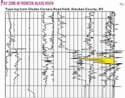
A type log from Glodes Corners Road field shows the pay zone (Fig. 2).
According to the New York State Department of Environmental Conservation,1 the first successful Trenton well in New York State was drilled in 1879 in Oswego County. This well led to the development of Sandy Creek field, which hosted 40 successful gas wells that provided the villages of Sandy Creek and Lacona with natural gas until the 1940s.
Pulaski field, also in Oswego County, was developed in 1888; this field hosted as many as 80 productive wells and supplied the local municipality with gas until 1946. North and South Fulton fields were also developed in Oswego County in the late 1800s-early 1900s. Both fields hosted a total of 12 wells. Production information is not recorded for these fields.
Around the same time, other Trenton discoveries were made in New York. In 1897, Baldwinsville field was discovered in Onondaga County. This field hosted a total of 60 productive wells in which gas from the Trenton, Queenston, and Medina formations was commingled. Baldwinsville field and Memphis field, also in Onondaga County, were productive until the 1920s.
In Oneida County, Rome field was discovered in 1898, and Camden field was discovered in the 1930s. These fields ceased production in the 1940s.
Natural gas was also discovered in Clyde field of Wayne County, Blue Tail Rooster field of Cayuga County, and Tug Hill field of Lewis County. No significant production was recorded from any of these fields.
There was a drilling boom for Trenton wells in the early 1960s, but while shows of oil and natural gas were encountered, no commercial production was established. The 1970s and 1980s saw infrequent Trenton exploration in the state.
The exploratory program of the middle to late 1990s has discovered four fields (Table 1). These are the first fields of the modern era that have produced from the Trenton-Black River.
Current understanding
According to the NYSDEC, Division of Mineral Resources,2 Glodes Corners Road field produces from a highly dolomitized Trenton-Black River pay that is located within a "graben" feature. According to state records, the graben is 7.5 miles long; it is up to 4,000 ft wide. On its eastern end, a transcurrent fault cuts the graben structure. Seismic data provided by anonymous sources confirm the presence a collapse feature easily recognized on reprocessed 2D seismic; it is this feature that has been used to delineate this graben structure.
Permit hearings conducted by the DMR have allotted spacing of 320 or 640 acres/well.
The Glodes Corners Road reservoir collapse feature, as revealed by seismic mapping, has been most often described as a hydrothermal dolomite reservoir facies. Hydrothermal dolomite is the name given to secondary dolomite emplacement.
A mineral rich hydrothermal fluid washed through regional limestone, primarily through localized fractures, and caused sufficient alteration of the limestone host rock to create a brecciated dolomite. This secondary dolomite forms an excellent reservoir rock, with both porosity and permeability. Davies3 and Reimer4 list the following characteristics for hydrothermal dolomite reservoirs:
- Often centered on breccia zones.
- Peripheral development of replacement dolomite (saddle facies), replacing regional limestone host.
- Best reservoir quality in replacement dolomite, not breccia zone, although some reservoirs have been found in the breccia.
- Reservoirs are noted for narrow width, high vertical continuity, thick reservoir potential, and often, a linear trend that can be compartmentalized.
- A synclinal depression forms at the top of a host unit above the main breccia or hydrothermal dolomite zone.
- The reservoir is formed in proximity to a major carbonate reef or shelf margin, and or to basement highs or arches.
- There is a close association with fault systems, often showing an association with a strike/slip displacement.
- There are overlying shale seals, referred to by Davies as pressure seals.
Saddle dolomite lines, fractures, and cements breccias, as well as replacing the surrounding host, and suggests hydrofracturing and possible boiling or effervescence and probable shallow (>500 m) depth.
Previously established models suggested a long, linear east west "graben" feature that controlled the limits of the field. A total of 15 wells was drilled along the mapped seismic feature. Of these, three were dry holes, four watered out, and eight are considered productive.
Of the productive wells, three are marginal and have shown signs of watering out, and five are strong producers. One can conclude that the developmental success of the seismic method was 5 wells out of 15 tests, or 33%.
NYSERDA study
In order to develop a usable exploration and developmental model for the Trenton, Direct Geochemical and Pyron Consulting, under the auspices of NYSERDA, completed an integrated study of the field using its IET methodology.
In June 2001, Direct Geochemical and Pyron Consulting initiated a detailed study of Glodes Corners Road field in order to develop an IET model.
Our past experience with this methodology has shown it to be a tool that has delineated charged reservoirs with precision. Our desire was to apply the methodology to a known field, anticipating that it would provide a consistent model that could guide exploration and lead to additional Trenton-Black River reservoir fields.
Soil gas samples were collected over an established, two-level grid which extended at least one half mile beyond the presently recognized boundaries of the field. Nearly 200 representative samples were collected during the field activities. These samples were shipped to Direct Geochemical's lab in Golden, Colo., for analysis, data interpretation, and mapping. The procedures used were similar to those described earlier.5 6
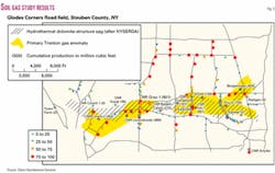
The results of the geochemical study are provided in Fig. 3.
Simultaneously, a subsurface study was completed for the area using well log information collected for the wells in Glodes Corners Road field and immediate vicinity. This information was used for both subsurface mapping analysis and petrophysical analysis. A remote sensing study was also completed using both multispectral satellite (MSS) and thematic mapper (TM) data. From this study, a regional lineament-tonal anomaly study was completed over this portion of south-central New York. The regional data helped in strengthening our localized model for the field proper.
The following results were observed from this study:
- The soil gas data provided positive indications for the presence of hydrocarbons. Further, when the data were interpreted and contoured, there was a strong correlation between paleogeomorphic thins and the interpreted Trenton gas anomaly.
- The subsurface paleogeomorphic map, though developed with a limited number of data points, revealed paleogeomorphic thins that are consistent with the best wells in the field.
- The regional remote sensing analysis indicated tonal anomalies suggestive of hydrocarbon in reservoirs. There are some E-W trending lineaments, but none of which completely paralleled the identified collapse structure.
- 4. When the paleogeomorphic map and the geochemical contour maps were integrated (Fig. 4), there was a strong match between paleogeomorphic thins and interpreted geochemical high spots for the given model. This suggests that the paleogeomorphic thins and geochemical positive areas can be correlated with a high degree of precision.
- Detailed analysis of the pay zones of the best wells in the field, plus communications with geologists who have examined Trenton-Black River cores, suggests that both the upper Black River, and possibly the Trenton, have been highly fractured.
What it means
Direct Geochemical and Pyron Consulting have successfully modeled the Glodes Corner Road field by integrating different data streams. From this new data, and by re-examining previous data and well log records, we have formulated a model that is applicable to the search for natural gas in the Trenton-Black River reservoir across the Appalachian basin.
The Glodes Corners Road field data collected by Direct Geochemical and Pyron Consulting suggests that the collected geochemical data successfully modeled the subsurface geology of the field. Regional subsurface mapping of the field using the paleogeomorphic mapping technique has revealed a strong correlation between the best producing wells in the field and the subsurface mapping interval. Thinning of the mapping interval can be correlated to the high volume wells in the field.
Addition of geochemistry supports the trend of subsurface data, effectively mapping the productive parts of the field. This suggests that the relatively high concentrations, as based upon soil sample analysis and comparative analysis, can be related to the best producing wells in the field. This in turn suggests that the collected data could model the best producing areas in the field and also can corroborate the subsurface mapping efforts.
In summary, the IET methodology has proven to be a cost-effective tool in locating a Trenton-Black River reservoir with limited surface and subsurface control. It has successfully identified the best wells in the field and has also identified optimum places for additional development.
References
- New York State Department of Environmental Conservation, "Historical Digest: Trenton and Black River Formations," in "NYS Oil and Gas Drilling and Production Report, 1986," September 1987, pp. 28-32.
- Anonymous, "Collected exploration information and perspectives on the Trenton Play," 2001.
- Davies, Graham R., "Hydrothermal Dolomite Reservoirs Global and Western Canada Perspectives," 2nd edition, prepared by GDGC, 2000, 214 p.
- Reimer, James D., "The Hydrothermal Dolomite (HTD) Play in Western and Eastern Canada: What have we Learned? Where are we Headed?," Presentation at the IOGA NY fall meeting, Buffalo, NY, 2001.
- Viellenave, J.H., Fontana, J., and Pyron, A., "Field Modeling-1: Three Exploration Methods Model Gas Field in New York," OGJ, Sept. 11, 2000, pp. 42-46.
- Viellenave, J.H., Fontana, J., and Pyron, A., "Field Modeling-2: How Integrated Exploration Technology Helped Answer Questions in an Appalachian Field," OGJ, Sept. 18, 2000, pp. 36-44.
Bibliography
Drazen, D.J., "Overview of Trenton Exploration and Development in New York State," in Keith, B., ed., "The Trenton Group (Upper Ordovician) of Eastern North America," AAPG Studies in Geology 29, 1984.
Hartnagel, Chris A., "The Medina and Trenton of Western New York," AAPG Bull., Vol. 22, No. 1, 1938, pp. 79-99.
Pyron, Arthur J., "What Exactly is Happening in the Appalachians," SIPES Newsletter, August 2001, pp. 1-7.
Robinson, Joseph E., "Development of Gas Bearing Reservoirs in the Trenton Limestone Formation of New York," NYSERDA Report 85-15, 1985, 100 pp.
Viellenave, J.H., Fontana, J., and Pyron, A., "Integrated Exploration Technology Targets Trenton-Black River and Shale Reservoirs," presentation at the IOGA NY Fall meeting, November 2001, Buffalo, NY.
The authors
Art Pyron is sole proprietor of Pyron Consulting. He has 20 years of experience in oil and gas exploration and appraisals, minerals investigations, environmental studies, and site remediation. He has an MS in geology from the University of Texas at El Paso.
Jim Viellenave ([email protected]) is a principal geochemist at Direct Geochemical Services in Golden, Colo. He has been involved in surface geochemical exploration for mineral, geothermal, and petroleum resources since 1978. Before that he was with NERI and Earth Sciences Inc. He holds degrees in geography from the University of California.
John V. Fontana is a principal geochemist at Direct Geochemical Services. He has been involved in surface geochemical exploration for mineral, geothermal, and petroleum resources since 1981. Previously he was with the geochemical exploration division of Analex Corp. He holds degrees in geology, physics, and oceanography from Humboldt State University.
