ARMENIA'S PROSPECTS —1: Armenia void of production but not without prospects
The Republic of Armenia is situated in the Transcaucasus, with Georgia Republic to the north, Azerbaijan to the east, Iran to the south, and Turkey to the west. The territory covers 29,800 sq km (similar in size to the state of Maryland). The 3 million population is quite homogenous and comprises 96% ethnic Armenians.
Armenia declared independence on Sept. 21, 1991, after being part of the USSR for almost 71 years. It has a republican form of government, along French lines, with a constitution requiring separate presidential and parliamentary elections every 5 years.
The current President, Robert Kocharyan, was elected Mar. 30, 1998, and will seek re-election in 2003. Despite political difficulties, mainly concerning the war over Nagorno Karabakh with Azerbaijan, and, more recently in October 1999, associated with the tragic assassination of Prime Minister Sargsyan, Speaker Demirchyan, and five others in parliament, there is political stability.
The economic situation in Armenia has improved significantly since the ceasefire with Azerbaijan in 1995, and increases in GDP average 5-6%/year. The energy supply situation improved dramatically from 1995 onwards following the restart of the Metsamor nuclear plant, which had been originally closed in 1988.
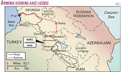
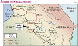
There are two principal means of access to Armenia for equipment and materials coming from abroad. Heavy equipment and supplies can be sent by sea to the Black Sea ports of P'ot'i and Batumi in Georgia Republic, and then loaded on road or rail transport, entering Armenia by the northern border. Personnel and smaller cargoes of materials can be flown directly to Zvartnots Airport, near Yerevan. There are several flights a week from West European airports such as London, Brussels, Vienna, Paris, and Frankfurt, as well as several flights a day from Moscow.
Armenia has one oil and gas exploration license (Fig. 1), operated by Armenian American Exploration Co. (AAEC).
Hydrocarbons in Armenia
The existence of hydrocarbons in Armenia is proven by oil recovered from the Shorakhpur-1P well 15 km due east of Yerevan, and the Oktemberyan-13E well, south-west of Armavir, which flowed gas for 6 months. Therefore, the right conditions for oil and gas accumulations exist.
The real question is whether commercial deposits can be found.
It is doubtful that large individual oil or gas fields exist in Armenia. Considering the complicated geological history, it is much more likely that any existing fields will be small and tectonically complex. However even such fields would have a significant economic impact, provided the average well productivity is high enough, and the oil price remains at reasonable levels (at least 250 bo/d at $16/bbl).
It is important to keep operational costs at a reasonable level. With a fully functioning drilling rig still in country, plus considerable amounts of ancillary equipment and materials, this should be possible.
Regional setting
Armenia lies within the Caucasian orogenic belt situated between the Black and Caspian seas.
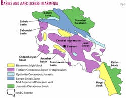
This orogenic belt was formed as a result of the closure of a number of Tethyan Ocean tracts since as long ago as the Devonian. The remnants of some of these paleo-oceans are represented in Armenia by up to three narrow, discontinuous belts of ophiolites, which are Jurassic to Cretaceous in age. These ophiolite belts serve to divide the country into a series of NW-SE trending tectonic zones (Fig. 2).
The southwestern zone is represented by three basins, the Oktemberyan, Artashat, and Surinaven. They lie along the course of the present day Araks River, which forms the border with Turkey. Their sedimentary section is Tertiary (mainly Oligocene-Eocene) in age and floored by ophiolites (Cretaceous or Jurassic in age) or Paleozoic sediments. The Oktemberyan basin, southwest of Armavir, is prospective for gas.
To the northeast, the section rises onto a regional high composed of Paleozoic metasediments, before dipping again into a large sedimentary basin known as the Central Depression, which has oil potential. These sediments range in age from Permian to Quaternary. The structure of this basin is complex, with folding, wrench faulting, and possibly thrust faulting present. Near the northwest end of the Central Depression lies the Aragats volcano, dormant since Pliocene times.
Early exploration
Serious exploration for oil and gas began in 1947. There have been two phases-the first, 1947-74, included the first borehole, Avan-1, drilled to 1,700 m in 1948; the second, 1981-90.
During the first phase, 55 deep wells and 115 structural/mapping wells were drilled. Shows of hydrocarbons were encountered in a number of them. In 1947-53, a systematic study of basin geology, combined with a gravity and surface magnetic survey, was conducted.
During the mid-60s additional gravity data were acquired in those areas identified as having exploration potential, including the Oktemberyan and Near Araks basins. Nearly 1,000 km of seismic data were acquired in the 1960s, but the low level of technology made the data of very limited exploration use.
Well Oktemberyan-13E tested gas at a rate ranging up to 1.54 MMcfd, the flow continuing for six months; other wells nearby recorded lower rates. Oil and gas shows recorded in Shorakhpur-31E led to further drilling on that prospect at a later date.
The USSR Ministry of Geology decided to terminate exploration activities in 1974. Soviet planners decided that exploration targets identified from this phase of exploration compared unfavorably with other areas in the USSR, which had lower exploration risk and were closer to existing production infrastructure.
The most significant result of the second phase was the recovery of about 1 cu m of oil from a Lower Eocene/Paleocene reservoir in Shorakhpur-1P. This was the first oil recovery of any significance in Armenia, albeit a small one.
In addition, the Oktemberyan-1P well tested the equivalent of 850 Mcfd of gas (54% methane, the rest mainly nitrogen) for a short duration from fractures in an ophiolite at 4,350 m depth, which indicated the presence of a deep mature gas source rock. Most drilling and seismic activities stopped during 1990, coinciding with the collapse of the Soviet Union.
Many boreholes have been drilled in Armenia, mostly for research purposes and few with serious commercial intent. Because of severe technical difficulties in obtaining adequate seismic data over areas covered with basalt, usable seismic data were not obtained until the 1980s. Most boreholes predated the seismic, so that only those drilled in the 1980s could have been located on seismically defined structures. However, for these last wells it is clear that seismic data were only used in a limited manner.
Moreover, drilling rates for boreholes were very slow, averaging less than 16 ft/day. Many boreholes took 2, even 3 years to drill (the Shorakhpur-1P well took over 4 years). This meant reservoirs were left exposed for long periods, with unsuitable drilling muds being used that could have suppressed possible oil reservoir flow.
The general motivation of Soviet-style exploration was for quantity (maximum number of meters drilled), often at the expense of quality. For instance, hundreds of kilometers of seismic data were acquired which completely lacked interpretable seismic reflections.
Since independence
In order to determine Armenia's real hydrocarbon potential, the Armenian government requested the assistance of the US Trade and Development Agency (USTDA).
A study was undertaken by consultants commissioned by the California Energy Commission during 1993-94. The work was based largely on a 2-week visit to Armenia during a winter of extreme hardship and used only a limited amount of material provided by several local experts.
The experts estimated Armenia's total hydrocarbon potential to be nearly 6.4 billion bbl of oil in place and nearly 6.2 tcf in recoverable gas. However, a large portion of these volumes was assigned to parts of the Central Depression (the Hrazdan and Urartu areas), which are only lightly explored.
During 1993-95 a group of concerned Armenian Diaspora businessmen made a serious attempt to fund the drilling of two exploration wells in the Oktemberyan and Shorakhpur areas. This was known as the Armoil project.
Unfortunately the project was never fully realized. However, modern seismic equipment was sent to Armenia as a result of this project, which was used later when seismic operations started during 1997.
From early on, the Ministry of Energy of the Republic of Armenia recognized the need to attract foreign investment into the country's energy sector and in particular for the development of potential indigenous hydrocarbons. It embarked on a program of legislative reform aimed at making Armenia an attractive place for foreign exploration companies to invest.
It also participated in a 1-year European Union (Tacis) sponsored project (undertaken by a Robertson Research of the UK and Partex Portugal consortium and completed July 1995). This project resulted in a comprehensive four-volume report on the hydrocarbon potential, the establishment of an exploration databank, and the setting up of a production-sharing type licensing policy.
As a result of these efforts, the business climate for foreign companies wishing to participate in petroleum exploration in Armenia was radically improved and negotiation processes streamlined.
A single state entity, Geoenergy cjsc, was established to act as the focal point for relations with foreign investors in the petroleum sector. It provides access to the exploration databank established during the 1995 Tacis project.
The 1995 Tacis study concluded that average resource-in-place prospects of 70 million bbl of oil (estimated 14 million bbl recoverable) exist in the Garni-Shorakhpur area, east of Yerevan (part of the Central Depression) and 144 bcf gas resource-in-place prospects (estimated 110 bcf recoverable) in the Oktemberyan basin area.
The study identified prospects and leads that totaled 1.775 tcf of gas in place and 422 million bbl of oil in place in the two main basins. However the estimated risk factors were high, the lowest risk recorded being 1 in 7 (14%).
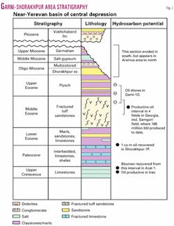
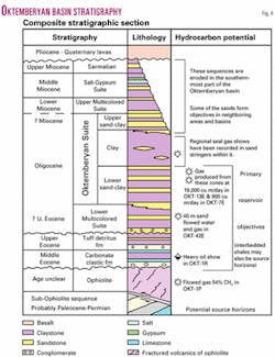
The general stratigraphic columns for the Garni-Shorakhpur oil prone area, east of Yerevan, and Oktemberyan Basin gas prone area, SW of Armavir, are illustrated in Figs. 3 and 4, respectively.
According to this study, only 16 wells in Armenia had been drilled on valid prospects. Of these, 13 penetrated the main objective, 3 did not, and 7 were inadequately evaluated. Of the other 6 wells, 4 were dry (Oktemberyan-13AE and 12E, Markara-5P, Garni-1P), while 2 were noncommercial gas wells (Oktemberyan-7P and 13E).
The lack of exploration success in Armenia (so far) is primarily due to the failure to identify and drill valid structures, although other factors such as reservoir quality are also very important.
Next: Hydrocarbon potential of Armenia's principal basins.
