EASTERN GULF OF MEXICO-1: A look at regional deposition under W. Florida shelf, slope
The Gulf of Mexico off Florida is one of the last US oil and gas frontiers. About 80,000 sq miles are covered there by the sea to a depth of 3,300 ft (1,000 m).
It is in the US's interest to:
- Identify the areas where exploitable volumes of petroleum could have accumulated off Florida.
- Determine whether such accumulations can be dry gas, gas-condensate, or light to heavy-grade oil.
- Ultimately appraise the likely magnitude of these resources.
This three-part article presents an assessment of the prospective late Jurassic and early Cretaceous section beneath the West Florida shelf and slope based on a new, regional synthesis of the depositional history and the petroleum habitat using public accessible information.
Carefully considered were previous assessments of the eastern Gulf of Mexico Outer Continental Shelf (OCS) by the US Minerals Management Service (MMS)1 and of Florida state waters and land by the US Geological Survey,2 with subsequent supplements.3 4 Faulkner and Applegate5 assessed the southern West Florida Shelf separately.
This article builds on and updates a preliminary summary by the author.6
Area and politics
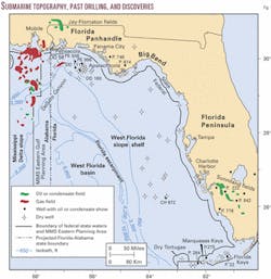
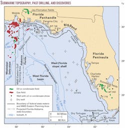
The submarine topography of the northeastern Gulf of Mexico is made up of the contiguous Mississippi-Alabama and West Florida shelves, the West Florida slope (terrace), the Florida escarpment, the deep West Florida basin with the DeSoto Canyon, and the eastern margin of the Mississippi Delta slope (Fig. 1).
The marine territory to three leagues (about 10 statute miles) from shore falls under Florida's jurisdiction. The federal government administers the OCS beyond Florida coastal waters through the MMS.
MMS separates its Eastern Gulf Planning Area from its Central Gulf Planning Area along an offset north-south line off Alabama and from its Atlantic Planning Area along an east-west line between the Dry Tortugas and the Marquesas Keys. The Florida-Alabama state line is projected here into the Eastern Gulf OCS along the longitude of the point at which that onshore line meets the Gulf of Mexico coast.
Twenty-three exploratory wells have been drilled in Florida and OCS waters between the Dry Tortugas and the Marquesas Keys under state permits. Elsewhere on the OCS off Florida, 39 more exploratory and appraisal wells have been drilled (Fig. 1).
The giant-class, so far for political reasons undeveloped Destin Dome Block 56 gas field was discovered on the OCS on the northern West Florida shelf in 1995. It is the largest pool found to date in the Mobile Bay Deep Gas trend1 and is currently the largest gas field in the US Gulf of Mexico. The field's importance lies also in the fact that it extends the highly prospective Mobile Bay Deep Gas trend by about 40 miles to the southeast, beneath the West Florida shelf.
Development of oil and gas resources on the West Florida shelf and slope is an ideological rather than a technical issue. Florida has objected to drilling there since 1987 to appease public fear of environmental impacts on Florida's scenic shoreline. The state closed all its coastal waters to petroleum activities in 1990 except for a lease held by one company.
That attitude has climaxed in the state's establishment of the policy to oppose federal lease sales within an arbitrarily designated 100 mile wide buffer zone.6 Pres. Bill Clinton postponed new OCS leasing on the West Florida shelf and slope until after 2012, except for Lease Sale 181 that took place in December 2001.
Following Florida's intervention in early 2001, the original Lease Sale 181 proposal was significantly reduced in size in an agreement between Florida Gov. Jeb Bush and Pres. George W. Bush by excluding from the sale the area within 100 miles from Alabama's coast. Military concerns about the eastern part of the original proposal were also addressed in the final sale proposal.
Depositional history
The petroleum bearing Late Jurassic and Early Cretaceous sediments, deposited during the Gulf of Mexico's ancestral and intermediate stage of development, occur in the sea some distance beneath the surface on the West Florida shelf, slope, and basin and on the adjoining land under the Florida Peninsula and Panhandle.
They form, together with the Mississippi-Alabama shelf, the gulf's geological Mesozoic province.1 That section is overlain by a terminal-stage Late Cretaceous and Cenozoic cover and is in part subaqueously exposed since its deposition in the submarine Florida escarpment.7 8
The Mesozoic sequence subsides along the here so-named DeSoto Canyon hinge line to the northwest under the overlying, several tens of thousands of feet thick section of the proto-Mississippi-sourced Cenozoic province in the central gulf.
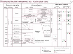
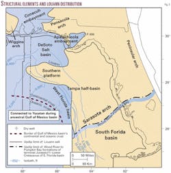
The first transgression into a restricted ancestral Gulf of Mexico rift basin from the Pacific Ocean,9 associated with salt and subordinately anhydrite deposition (Louann- Pine Hill formations, Fig. 2), had reached to a topographically differentiated land in the east, which is buried today under the Florida Panhandle and the West Florida shelf (Fig. 3).10 11
North of the promontory of the Southern platform8 9 to the promontory of the Pensacola arch12 had formed the DeSoto Salt basin and south of that platform to a protruding land, the highest portion of which is represented by the Sarasota arch,10 had formed the West Florida basin.
The DeSoto Salt basin had extended far into the Apalachicola embayment (well Permit No. 696), and the West Florida basin had reached into the distal Tampa half-basin.8 13 Wells drilled in the DeSoto Salt basin have bottomed in Louann salt.1 12 14 The identification of Louann salt in the West Florida basin is based on seismic recognition of salt diapirism.8 15
Louann salt terminates in the south in the deep West Florida basin,9 at the transition from continental to oceanic crust.16 17
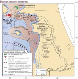
A regional regression followed (Fig. 4). Terrestrial deposition (Norphlet formation, Fig. 2) had prevailed on top of a wide coastal Louann Salt belt and probably also on some low-lying adjoining land. The delineation of the transition from terrestrial to marine Norphlet deposition is controlled on the northern DeSoto Salt basin margin by a well on Pensacola Block 973 that penetrated the marine facies of shale and micrite.1 12 18
The terrestrial belt is projected in this assessment from the northern De-Soto Salt basin margin around the eastern DeSoto Salt basin margin and the Southern platform into the Tampa half-basin, assuming a width of terrestrial deposition comparable to the northern DeSoto Salt basin margin. It is conceivable that most of the Southern platform had converted soon after Louann deposition into a terrestrial depression in which thick Norphlet sediments had accumulated.
None of the three wells drilled on the perimeter of the Tampa half-basin on Florida Middle Ground Block 252, Saint Petersburg Block 7, and The Elbow Block 915 penetrated any Norphlet section before reaching basement.
The terrestrial Norphlet formation terminates most likely also in the deep West Florida basin at the boundary between continental and oceanic crust.
A second pulse of regional transgression onto the ancestral basin margin had resulted in deposition of Smackover carbonate (Fig. 2) on a regional ramp,19 20 that had expanded partly eastward beyond Louann salt distribution (Fig. 4).
The updip Smackover pinchout is controlled by wells on the Florida Panhandle coast but is still only vaguely defined by seismic on the central West Florida shelf.8 The wells on Florida Middle Ground Block 252, Saint Petersburg Block 7, and The Elbow Block 915 on the perimeter of the Tampa half-basin did not encounter any Smackover section.
The Southern platform had drowned up to the successor Middle Ground arch during Smackover time, except for a small land at the tip of the platform (here named DeSoto high).8 The outer limit of the carbonate ramp coincides perhaps with the boundary between terrestrial and marine Norphlet deposition.
No deposits coeval with the Smackover formation have been identified on the Southern Florida Peninsula (Fig. 2).10 A considered continuation of the Smackover formation beneath the South Florida Peninsula as part of the Wood River formation21 is not supported by biostratigraphic information.9 22
The Smackover carbonate ramp had terminated most likely in the deep West Florida basin at the transition from continental to oceanic crust (Fig. 4).
Carbonate sedimentation had ceased on the eastern ancestral Gulf of Mexico basin margin soon after the Smackover transgression had reached its maximum extent. A second, minor regression had led to evaporitic-pelitic deposition over Smackover carbonates (Buckner-Haynesville formations, Fig. 2).10
On the southern West Florida shelf, the sea access from the proto-Atlantic Ocean into the Gulf of Mexico basin since the early intermediate stage had been associated with deposition of basal clastics and overlying, thick carbonates and evaporites in a new South Florida basin above a low-lying land (Fig. 3; part of the Southeastern Sedimentary province of Winston10).
The Wood River formation,23 of late Tithonian(?) to Berriasian(?) age,22 24 is overlain by the Bone Island and Pumpkin Bay formations (Fig. 2).23 The latter two formations had fringed the flank of the Sarasota arch (Figs. 2, 3).10 21 25
Since the end of ancestral Gulf of Mexico basin deposition and contemporaneous with these three carbonate-evaporite formations, erosional debris from the Appalachian fold belt, piedmont, and foreland had accumulated in a regional basin north of the Sarasota arch (Northwestern Sedimentary province of Winston;10 Cotton Valley and Hosston formations, separated by a hiatus, Fig. 2). These clastic sediments had graded seaward to limestone (Knowles and Sligo formations, Fig. 2).10
Following full submergence of the Sarasota arch near the end of Pumpkin Bay time, more stacked carbonates and anhydrites (Glades, Ocean Reef, Big Cypress, and Naples Bay groups, Fig. 2) had built out during the late intermediate stage from the South Florida basin to the northwest into a regional shelf.19
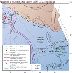
There, carbonates and anhydrites had spread unhindered and replaced largely earlier clastic sedimentation (Fig. 2, 5). Rudist buildups had fringed during that stage the shelf edge as a bioclastic barrier (James and Andrew formations, Fig. 2) and had occurred elsewhere in patches on the shelf as bioherms (Sunniland formation, Figs. 2, 5). The barrier is mostly eroded off Florida in the Florida escarpment due to its continuous submarine exposure.10 17
The regional correlation of anhydrites from the South Florida basin into the northwestern shelf26 attests to the uniformity of deposition. The shelf margin in the north remained under terrestrial influx (Paluxy and Dantzler formations, Fig. 2). By the end of Paluxy time, the ancient Peninsular arch had largely drowned (Fig. 5).10 25
Next: Eastern Gulf of Mexico petroleum habitat.Klaus Gohrbandt