Petroleum potential of an emerging giant gas province, Nile Delta and Mediterranean Sea off Egypt
The Nile Delta and Mediterranean deepwater trend along the northern coastline of Egypt is an emerging giant gas province situated ideally for markets in the circum-Mediterranean region. Deep potential remains largely untapped and may hold the key to the ultimate basin resource.
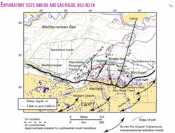
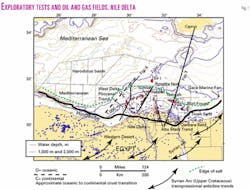
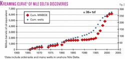
Over 36 trillion cu ft of gas has been discovered from 276 exploratory tests since initial drilling began in 1966 (Figs. 1 and 2). Over 25 tcf of this reserve growth has occurred since 1995.
This explosive growth has been dominated by exploration for Pliocene age reservoirs shallower than 2,000 m below mud-line. These targets can easily be detected seismically by direct hydrocarbon indicators (DHIs), resulting in a 90%+ industry success rate.
Initial success in the Pliocene trends began in shallow water growth fault traps in the Temsah and Port Fouad in the eastern delta. Since 1998, the Pliocene play has extended into deep water (> 500 m), where over 12 tcf has been discovered in slope-channel turbidite systems.
Geological and geophysical data gathered in this and other studies, however, suggest these accumulations are shallow "seeps" above deeper and larger accumulations that remain untapped. This article builds on work by Dolson and Boucher.1
Hydrocarbon setting
Dolson et al.1 2 3 have interpreted the geological framework of the Nile Delta within the context of major tectono-stratigraphic sequences in Egypt.
Recently acquired regional seismic data and results from a multi-industry basement study4 show the Nile Delta positioned between four major tectonic elements. Additional information on the evolution of the Nile Delta is available in Harms and Wray.5
The most fundamental element is the intersection of a prominent basement controlled ridge forming the western edge of the Cretaceous shelf edge ("hingeline" on Fig. 1) and the northeast-southwest oriented Rosetta fault system.
East of the Rosetta fault system, a series of deep Jurassic and Early Cretaceous Tethyan margin fault blocks (not shown) and basins extend under the Nile Delta from the Western Desert northeastward toward Cyprus.4
These basins, which underlie the main productive part of the Nile Delta, are most likely filled with continental and marine source rocks in Jurassic rift blocks that may contribute to the charge of the overlying reservoir section. West of the Rosetta fault, a series of deep faults progressively drop basement into the Herodotus basin. Fig. 1 shows the approximate westward transition from continental to oceanic crust.
A second element is a series of large northeast-southwest oriented folds south of the delta that formed during the "Syrian Arc" transpressional event from Upper Cretaceous (Santonian) through early Oligocene time.6 The "hingeline" shown on Fig. 1 is an Upper Cretaceous carbonate shelf edge that forms the southern boundary of thick Neogene sediments in the Nile Delta. Lastly, thick Messinian age salt deposits blanket the deepwater setting outboard of the dashed green line shown on Fig. 1, creating subsalt plays and associated challenges.7
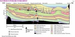
The proven commercially viable hydrocarbon system lies dominantly north of the Hingeline and south and east of the untested subsalt trends. The major tectonic elements shown have created significant differences between the eastern and western portions of the Nile Delta. Fig. 3 summarizes the petroleum systems context for the eastern delta. This generalized northeast-southwest section illustrates some fundamental structural changes that occur between Plio-Pleistocene and pre-Pliocene strata on the eastern side of the Nile Delta.
Large structural closures such as the Temsah anticlinorium shown on Figs. 1 and 3 occur throughout the pre-Pliocene, many in excess of 150 sq km. Over 50 of these deep closures have been identified with recent seismic data, yet only a relative handful have been tested. Most of these structures are pre-Messinian in age (> 5.0 MA). Giant gas-condensate fields in these structural trends include the Temsah-Akhen anticlinorium, Port Fouad, and Wakar fields.
These fields are usually masked at shallow levels by unconformities associated with the Messinian dessication event.8 This event was caused by structural closing of the Mediterranean at the Straits of Gibraltar, resulting in thick basinal salt deposits and Grand Canyon scale incisions throughout the Mediterranean coastline. Canyons as deep as 500 m and as wide as 100 km were developed.
Fluvial point bar and estuarine facies9 are productive in the Messinian age Abu Madi valley trend (Fig. 1). The north-south trend of fields within the Abu Madi system may have resulted from "thiefing" of vertically migrated of hydrocarbons from these deeper closures.
In the eastern delta, a growth fault province located over a Messinian "salt withdrawal" trend completely masks the underlying giant structural belts.
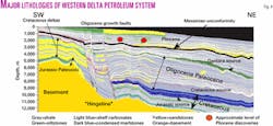
Fig. 4 contrasts this area with a seismic line tracing of a similarly oriented line in the Western Delta. Unlike the eastern delta, a growth fault province is not present westward in Plio-Pleistocene strata. Pliocene age traps in the western Delta are generally slope-channels draped over noses or four-way closures propagated vertically from the deeper structural blocks.
Known source rocks occur from Middle Jurassic through Middle Miocene strata. Major Tertiary source rocks appear to be in the Middle Miocene Qantara formation and dispersed throughout the Oligocene strata. Additional source strata may be present in Eocene condensed section offshore, but no penetrations have been made of this horizon.
In any event, data from head space gas and condensate from wells and fields indicate that thermogenically derived gases have migrated vertically as high as Pleistocene levels in the delta, with many shallow fields containing a mix of biogenic and thermogenic gases. In most cases, however, in both the eastern and western delta, the position of Plio-Pleistocene accumulations as well as leads detectable with DHIs generally occur over the deep structures, strongly suggesting that these deeper structural blocks serve as focal points for vertical migration.
Penetrations and deep potential
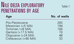
Table 1 quantifies the general lack of deep exploratory drilling. Proven reservoir fairways extend as deep as the Upper Eocene. Despite this, the bulk of the penetrations stop at the Upper Miocene Messinian level, leaving deeper, more liquid-rich and overpressured targets untested.
Thick Oligocene fill in the basin (Fig. 4) is probably accompanied by major basinward translation of reservoir facies as North Africa was titled northward tectonically during opening of the Gulf of Suez rift. Evidence for this is drawn from pronounced unconformities documented in outcrops to the south in the Fayoum basin10 and from seismic facies analysis.1
The authors speculate that the entire hingeline was subaerially exposed intermittently from latest Cretaceous through Oligocene time. As a result, lowstand wedges of clastic sediment repeatedly entered the basin from a number of input points to the south, shedding shallow water facies into what is now a deepwater province. Canyon incisions up to 300 m deep eroding Eocene and Cretaceous sediment are visible from seismic along the hingeline trend, with at least 12 entry points defined.
Commencing in the late Eocene, a major regression caused progradation of deltaic sediments northward. Southernmost shelf edges preserved onshore in Upper Oligocene and Lower Miocene time moved basinward to within 20 km of the Temsah field complex by 10.5 MA. This event culminated in deep erosion of the older deltaic packages by the Messinian unconformity between 8.0 and 5.0 MA. Adequate shale seals deposited during the subsequent lower Pliocene transgressions as the Mediterranean re-filled were largely emplaced over the entire pre-Pliocene package by 3 MA.
Only 48 wells penetrate to the top of the Oligocene, and most of these wells are onshore, drilled in Oligocene-age rotated fault block plays in a growth fault province paralleling the shelf edge. This play has proven unsuccessful to date.
Other onshore deep tests targeted Cretaceous objectives that have also proven largely unsuccessful. Offshore, where thick Neogene sedimentation has created the best source rock/reservoir kitchen, there are only 12 key penetrations. The 1999 Habbar-1 well, although a noncommercial success, proved viable reservoir, hydrocarbons, and permeability at 4,500 m below mud-line in lower Miocene and Oligocene strata.
Most other offshore Oligocene tests were from 2D seismic data primarily targeting shallower Serravallian horizons drilled without the benefit of seismic techniques now commonly used with 3D seismic for reservoir delineation. These other tests either encountered no reservoirs or were drilled off-structure.
The stratigraphically deepest commercial pay has been established in the middle Miocene Qantara formation at Qantara field (Fig. 1). Noncommercial oil at high rates and pressure was established at an Oligocene slope-channel stratigraphic trap at Tineh field.11
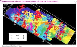
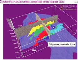
The geometry of the shelf edges in pre-Pliocene strata is such that the dominant play fairway inboard of the Messinian salts consists of stacked submarine channels and levees. Fig. 5 shows a 3D image of Serravallian age (14.8 MA) channel trends along the Temsah/Akhen anticlinorium. Fig. 6 shows a similar view of Tortonian (10.5 MA) to Oligocene age channel systems draped over large undrilled structural blocks in the western delta.
Pressures
Overpressures commence in portions of the Nile Delta in the lowermost Pliocene.12 Most of the overpressured hydrocarbon accumulations, however, are associated with pressure regressions.13
Pressure regressions are defined as being present where the encased reservoir pressures are lower than those of the surrounding shales. Reservoirs undergoing a pressure regression form pressure sinks for hydrocarbon migration and entrapment. Although productive reservoirs can be found in lenticular sandstones that bear the same pressure as the surrounding shales, most accumulations to date in the Nile Delta have been found in the reservoirs undergoing regression.
The extent of the regression is related to the volume of the reservoir facies and its lateral connectivity to the basin margins. The main sand fairway in the Abu Madi Messinian valley trend, for example, is in full pressure regression to hydrostatic (0.43 psi/ft).
In contrast, shale filled tributaries to the Abu Madi canyon system and isolated sand lenses are not in regression. In these latter reservoir-poor trends, accumulations have proven to be small and highly overpressured.
Partial pressure regressions occur in strata that do not eventually link up with outcrop belts structurally or stratigraphically but have extensive enough sand development to form overpressured reservoirs that remain less pressured than the encasing shales. A good example is the Serravallian slope channels at Temsah field, which are overpressured at 12.5-13 lb/gal while the shales are at 15-16 lb/gal.
Throughout the eastern delta, where reservoir is present, the Serravallian and Tortonian age channel reservoirs are in partial regression. No reservoir facies of equivalent age or environment have been tested anywhere in the Western Delta slope-channel fairways. The noncommercial Tineh Oligocene channels, in contrast, are not in regression, but pressure regressions have been observed in some other Oligocene penetrations.
The key to commercially successful pre-Pliocene discoveries may well be related to the ability to locate and drill extensive reservoir belts that have the most likelihood of having significant pressure regressions.
Fan fairway
Most industry activity will continue for some time to concentrate on stacked submarine channel fairways, both in the Pliocene and pre-Pliocene.
Recently, however, British Gas drilled the offshore Gaza Marine discovery in Palestinian waters14 (Fig. 1). This 1-2 tcf field is in a large Lower Pliocene turbidite fan. This giant field has a much simpler reservoir architecture than any slope system drilled to date.
Shell tested a small gas discovery in 2001 in the Leil-1 location, making the farthest northward extension of the gas plays into deep water (Fig. 1). This well reportedly tested another fan facies.
It is likely that fan fairways roughly follow the trend of the Messinian salt basin and remain a prospective new fairway in deep water. The potential for a simpler reservoir architecture may provide additional incentive to test this fairway, even in a subsalt setting.
Challenges
The Nile-Mediterranean province is one of the few deepwater gas provinces in the world, and many lessons will be learned in the coming years as to how to exploit and develop these fields economically.
The potential for compartmentalization in the slope-channel fairway is high.15 16 Perched water has been encountered in most of the new fields. Perched zones occur when gas is not fully flushed during migration. Gas in continuous phase accumulations can be developed completely around and below these perched water horizons, but the size and volume of the compartment can be difficult to determine and diminish the volume of gas-in-place.
Subsea completions and the need for future well interventions or downhole monitoring also provide significant challenges for development. In addition, it is highly likely that multiple vertically stacked pressure regimes will be encountered in pre-Pliocene strata in any given well bore, causing drilling and completion challenges.
Per well reserves remain the single most economically important question to ask in any development. Given the complexity of the reservoir facies and high potential for compartmentalization, lack of analog dynamic data or any long-term test data to date, a wide range of values is possible at each location.
As infrastructure grows, however, it will become increasingly attractive to tie smaller satellite fields into larger hub networks.
Summary and future
Current industry drilling activity targets the shallower DHI-driven Pliocene "bright spot" play, but the mature source rocks are much deeper in the basin at the Lower Miocene Qantara and Oligocene or older levels.
Deep structural closures may provide a strong upward "focus" for migration. As a result, drilling deeper into these migration pathways and into the large structural closures that contain thick reservoir fairways may result in a significant reserve growth in the basin.
If the Pliocene accumulations ultimately turn out to be "seeps" above the deeper structures, the Nile Delta may one day emerge as a true giant gas province. Based on statistical distributions complete to January 2000 from known fields alone, Dolson et al.2 speculated a yet-to-find resource of 65-84 tcf.
Since then, roughly 8 tcf of this resource has been found. The petroleum systems modeling that underpins the conclusions of this article suggests that the potential exists, by learning how to exploit the deeper targets, to become a basin with 100 tcf+ ultimate potential.
Acknowledgments
Thanks to BP-Egypt for permission and encouragement to write this article and to a host of coworkers who contributed enormously to BP's current view of the Nile Delta/Mediterranean province.
References
- Dolson, J.C., and Boucher, P.J., "The Petroleum Potential of the Emerging Mediterranean Offshore Gas Plays, Egypt," AAPG annual meeting abs., Houston, Mar. 10-14, 2002.
- Dolson, J.C., Shann, M.V., Matbouly, S., Harwood, C., Rashed, R., and Hammouda, H., "The Petroleum Potential of Egypt," in Downey, M.W., Threet, J.C., and Morgan, W.A., eds., "Petroleum Provinces of the 21st Century," AAPG Memoir 74, 2001, pp. 453-482.
- Dolson, J.C., Shann, M.V., Matbouly, S.I., Hammouda, H., and Rashed, R.M., "Egypt in the twenty-first century: petroleum potential in offshore trends," GeoArabia, Vol. 6, 2000, pp. 211-229.
- Loutit, T., Allard, D., Dolson, J., Schruers, J., and Laura, S., "A new view of Egypt's hydrocarbon potential," proceedings of the Middle East and North Africa Conference, London, abs., in MENA 2001 Oil and Gas Conference (The 2nd Middle East and North Africa Oil and Gas Conference), Target Exploration, Sept. 18-19, 2001, Imperial College, London, 350 p.
- Harms, J.C., and Wray, J.L., "Nile Delta," in Said, R., ed., "The Geology of Egypt," A.A. Balkema Publishers, Rotterdam, 1990, pp. 329-344.
- Moustafa, A.R., and Khalil, M.H., "Structural characteristics and tectonic evolution of north Sinai fold belts," in Said, R., ed., "The Geology of Egypt," A.A. Balkema Publishers, Rotterdam, 1990, pp. 381-392.
- Aal, A.A., Barkooky, A.E., Gerrits, M., Meyer, H., Schwander, M., and Zaki, H., "Habitat and exploration potential of the ultradeepwater offshore Mediterranean," proceedings EAGE Geology and Petroleum Geology of the Mediterranean and Circum-Mediterranean Basins, 2000, p. C-39.
- Halbouty, M.T., and El-Baz, F., "The Mediterranean region: its geologic history and oil and gas potentials," in Sadek, A., ed., "Geology of the Arab World," Cairo University, 1992, pp. 15-60.
- Dalla, S., Harby, H., and Serazzi, M., "Hydrocarbon exploration in a complex incised valley fill: an example from the late Messinian Abu Madi formation (Nile Delta basin, Egypt)," The Leading Edge, Vol. 16, 1997, pp. 1,819-24
- Bown, T.M., and Kraus, M.J., "Geology and paleoenvironment of the Oligocene Jebel Qatrani formation and adjacent rocks, Fayum depression, Egypt," USGS Professional Paper 1452, 1988, pp. 1-60.
- Moussa, D.S., and Matbouly, D.S., "Nile Delta and North Sinai: Fields, Discoveries and Hydrocarbon Potentials (A Comprehensive Overview)," Egyptian General Petroleum Corp., Cairo, 1994, p. 387.
- Nashaat, M., Carlin, S., Bagnoli, G., and A. Moussa, A., "The pre-Messinian overpressure study in the Nile Delta area: a supporting methodology of understanding hydrocarbon accumulation," in Youssef, M., ed., 13th Petroleum Conference, Cairo, EGPC, 1996, pp. 193-202.
- Heppard, P.D., Dolson, J.C., Allegar, N.C., and Schultz, S.N., "Overpressure evaluation and hydrocarbon systems of offshore Nile Delta, Egypt," Proceedings of the 6th Mediterranean Offshore Conference, Alexandria, Egypt, 2000.
- Maddox, S.J., "The lower Pliocene gas sands of offshore Israel and Gaza-a new play in the Eastern Mediterranean Basin," proceedings EAGE Geology and Petroleum Geology of the Mediterranean and Circum-Mediterranean Basins, St. Julians, Malta, 2000, p. C-47.
- Samuel, A., Sharp, A., Sitta, A., Millington, J., and Worku, T., "Deep water slope channel reservoirs from the Nile Delta, Egypt," proceedings EAGE Geology and Petroleum Geology of the Mediterranean and Circum-Mediterranean Basins, 2000, p. C-41.
- Sharp, A., Samuel, A., and Federici, F., "Geophysical characterization of the Simian discovery, West Delta Deep Marine Concession, Nile Delta, Egypt," proceedings EAGE Geology and Petroleum Geology of the Mediterranean and Circum-Mediterranean Basins, 2000, p. C-39.
The authors
John Dolson is a senior geological associate with BP Egypt in Cairo. He has over 23 years of experience in petroleum exploration, with specialized expertise in integrated sequence stratigraphy and play fairway analysis. He holds a BA in natural sciences from Colorado College and an MS in geology from Colorado State University.
Paul Boucher is a senior geophysicist with BP Egypt. He has 7 years' petroleum exploration experience in the Nile Delta basin and Eastern Mediterranean. His expertise is in 3D seismic interpretation and integrated basin analysis. He holds a BS in geology from Salem State College and an MS in geophysics from Texas A&M University.
Tim Dodd has over 18 years' experience in the petroleum industry. He has been with BP since 1988. His specialty is petroleum systems and basin modeling, and location in Cairo has exposed him to all major Egyptian basins and petroleum systems. He has a BSc in geology and an MSc in geochemistry from the University of Newcastle.
Javed Ismail joined BP as a petroleum systems analyst in 2001. He has been working in the Cairo office since July 2001 and has gained extensive insight into the Nile Delta and Western Desert petroleum systems. Before joining BP he worked 3 years for Robertson Research International. He has an MSc in fossil fuels and environmental geochemistry from the University of Newcastle.
