Alaska's Interior rift basins: a new frontier for discovery
Gerald K. Van Kooten
Petrotechnical Resources Alaska
Anchorage
Michael Richter
Michael Richter Exploration Consulting
Franktown, Colo.
Pierre A. Zippi
Biostratigraphy.com LLC
Garland, Tex.
Oil and gas production in Alaska has historically been limited to the northern and southern margins of the state, primarily in the North Slope and Cook Inlet, but recent drilling, seismic, and exploration data in Interior Alaska suggests potential for large oil and gas fields in rift basins near Nenana and Yukon Flats.
Seismic depth calibration to the Nunivak-1 well, drilled to 11,136 ft (11,075 ft true vertical depth) in 2009, suggests the Nenana basin is about 25,000 ft deep. Inversion of gravity data and a gravity-aeromagnetic basement interpretation support these basin depths and show the general basin architecture.
Geochemical (RockEval) analyses from Nunivak-1 highlight marginally mature Late Paleocene coal and coaly shale with excellent source potential. These coals generate impressive RockEval S2 peaks up to 189 mg/g (average 90 mg/g) and HI up to 379 (average 240).
Using the temperature gradient observed in the Nunivak-1 well, basin geohistory modeling and calculations suggests coaly source rocks below 13,000 ft have expelled billions of barrels of oil. Supporting the potential for prolific expulsion, surface soil cores and lake bottom sediment samples contain thermogenic oil from C2 to C6 in parts per million quantities.
Fluorescent spectral analysis of surface samples detects surface oils of moderate gravity in the C6-12 range. A robust source system appears to be in place. Only one deep well has been drilled in these rift basins, and additional seismic and drilling is needed to evaluate their hydrocarbon potential.
Structure
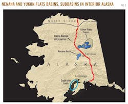
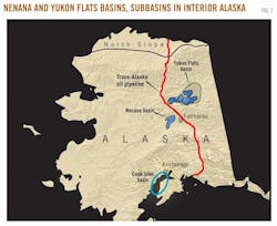
Several nonmarine rift basins formed in interior Alaska (Fig. 1) in response to crustal extension (Nenana basin) and strike slip movement along curved, regional faults (Yukon Flats).
The Yukon Flats includes about 12,000 sq miles and consists of several rift subbasins that formed on the northern margin of the right-lateral Tintina fault. Within the Yukon Flats, large normal faults have localized subsidence, but the entire region has also experienced structural sag and sedimentary deposition, probably intermittent, since the Late Cretaceous.
Judging by surrounding outcrops, the sedimentary rift basins developed on plutonic and metamorphic basement rocks. The Nenana basin, located southwest and separate from the Yukon Flats, is a structural half-graben with a large, normal basin bounding fault on the southeast margin. This fault forms an asymmetrical basin with a relatively steep southeast and a gentle northwest flank.
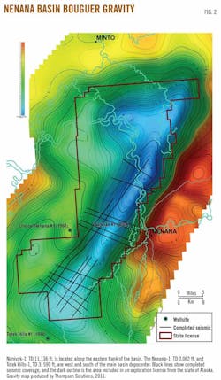
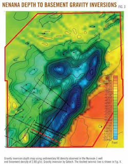
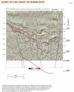
New surface gravity data collected in the northern part of Nenana basin are incorporated into the Bouguer gravity map and show the basin geometry (Fig. 2). The Nenana basin is elongate in a NE-SW direction, covers about 2,000 sq miles, and widens in the north. The Bouguer gravity map indicates that the deepest part of the Nenana basin is generally in the north. The depth of the Nenana basin is important in developing a robust and prolific oil kitchen. A gravity inversion basement map shows the maximum basin depth is about 30,000 ft (Fig. 3).
The density inversion used density indicated by logs from Nunivak-1 (11,075 ft TVD) for sedimentary fill and an assumed basement density of 2.80 g/cc. Increasing basement density to a less reasonable 2.95 g/cc decreases the basement depth to about 21,000 ft. An integration of gravity and aeromagnetic data to yield a depth to basement interpretation (not shown) is consistent with depths shown in Fig. 3.
The asymmetry of the Nenana basin is evident on the dip-oriented seismic line in Fig. 4. From an exploration point of view, the gentle western flank is generally considered more prospective than the steep eastern flank because of the potential for larger volume under closure and larger fetch areas.
Fig. 3 shows a structural nose extending to the NE in the northern basin between two sedimentary deeps. Hydrocarbons could potentially migrate onto this nose from three sides, and this feature is an attractive lead. Past exploration efforts, discussed below, focused on the southern part of the basin.
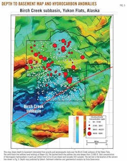
The structure of the Birch Creek subbasin in the Yukon Flats is shown in Fig. 5, a depth to basement interpretation based on gravity and aeromagnetic data. It shows a large deep in the southwest with basin depths to about 21,000 ft.
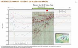
Using the depth contours on Fig. 5, sediment below 13,000 ft occurs over about 360 sq miles. This depth approximates the beginning of hydrocarbon expulsion in the Nenana basin, also discussed below. Using a depth of 6,000 ft for the top of the oil window, as suggested by Rowan and Stanley,1 dramatically increases the volume of thermally mature sediment. A seismic line through the Birch Creek subbasin is shown in Fig. 6.
Surface soil cores and lake bottom sediments were sampled in the Nenana basin and Yukon Flats. In the Yukon Flats, C2 through C6 thermogenic hydrocarbons were detected in lake sediment samples from the Birch Creek subbasin at the parts per million level (Fig. 5). Fluorescent spectral analyses detected C6 to C12 hydrocarbons that have similar spectral patterns to medium gravity oil.
In Fig. 5, no surface anomalies occur over the deep Birch Creek subbasin, but anomalies are associated with updip structural highs. These surface hydrocarbons are viewed as evidence of an active oil system with maturation, generation, and migration from the deep basin region onto the surrounding margin. The surface anomalies may occur where migration pathways intersect structural elements (for example, faults) associated with structural highs and divert towards the surface. Similar thermogenic hydrocarbon anomalies were detected near Stevens Village, another subbasin in the Yukon Flats, and the Nenana basin. Oil source rocks are thought to be thermally mature in each of these areas.
Stratigraphy
Only one deep test has been drilled to date in the Interior Alaska rift basins. The Nunivak-1 well, drilled in 2009, encountered entirely nonmarine fluvial and lacustrine rocks in the Nenana basin.
The upper 4,500 ft in Nunivak-1 is Nenana gravel, a clastic unit of predominately sand with occasional gravel or conglomerate (Fig. 7). These sediments are thought to be deposited during the Pliocene and possibly latest Miocene by coalescing alluvium fans during uplift of the Alaska Range to the south.2 Although the GR curve indicates occasional siltstone above 1,000 ft, lack of seals in the Nenana gravel limit the reservoir potential of this section.
The Miocene Usibelli Group underlies the Nenana gravel and is composed of five individual formations (Fig. 7). Coal occurs at the top and intermittently throughout the Usibelli Group and is surface mined at the nearby town of Healy. Sandstone, mudstone, and coal represent swamp, lake, and fluvial environments associated with south-flowing streams before uplift of the Alaska Range.2
The mud log notes five horizons from the Usibelli Group contain micrite (lithified carbonate mud), indicating a freshwater lacustrine depositional environment. Claystones also may represent lacustrine deposition and the upper and lower Usibelli Group is dominated by fine grained deposits (Fig. 7). Color of pollen and spores indicate the Usibelli Group is immature (est. Ro = 0.4), although C1 to C4 trace gas shows are present below about 7,000 ft. Visibly outgassing coals were encountered from 7,600 ft to 7,900 ft. Coals from the lower Usibelli Group have source potential for oil and are discussed below.
The Usibelli Group rests on a major unconformity surface. Age assignments based on palynology indicate missing section with ages from 54.8 to 23.8 million years, producing a time gap of 31 million years covering the Eocene and Oligocene. It is uncertain how much material was deposited and subsequently eroded, but the unconformity likely records compression accompanied by uplift. Compressional folds formed during uplift may be truncated by the erosional unconformity and subsequently overlain by fine-grained seals of the lower Usibelli Group, potentially forming attractive trapping geometries. Subtle drape folds, formed by differential compaction, may also overlie deeper compressional folds.
Late Paleocene rocks are present in Nunivak-1 from 8,110 ft to TD (Fig. 7). This section correlates in time to the Paleocene Cantwell formation,2 but in Nunivak-1 these rocks are composed exclusively of nonmarine clastic units representing fluvial, lacustrine, swamp, and possibly alluvial fan environments. Igneous rocks common in outcrops of the Cantwell formation, such as extrusive volcanic rocks, intrusive sills, and dikes, and plutonic granitoids, are missing in Nunivak-1. Other Cantwell outcrops are composed of nonmarine clastic rocks, and Nunivak-1 is considered correlative to these.
The Late Paleocene is dominated by fine grained rocks (Fig. 7) with occasional sand, such as an 80-ft thick sandstone at about 9,300 ft. Coal is common and has excellent oil source potential, as discussed below. The mud log notes four occurrences of micrite in the Late Paleocene, indicating freshwater lacustrine deposition, and trace oil stain, fluorescence, and cut in several horizons. Gases from C1 to C4 were noted throughout most of the section, and C5 was detected over a 200-ft interval near 9,800 ft. Sands are arkoses but become increasingly lithic-rich below 10,000 ft. The increase in metamorphic lithics near TD may signal proximity to basement or a fault.
Source rocks
Identification and characterization of adequate hydrocarbon source rocks is critical for evaluating the hydrocarbon potential of a sedimentary basin and providing a rationale for further work. Surface outcrops provide useful information, but subsurface samples are free from surface alteration and oxidation and are likely more closely related to rocks in the basin center.
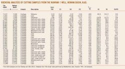
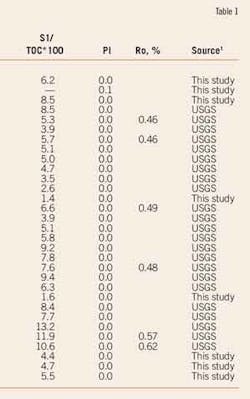
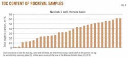
Table 1 shows RockEval analyses of cuttings from the Nunivak-1 well. Twenty-seven Late Paleocene samples below 8,110 ft are lithologically coal, coaly shale, or coaly siltstone. Total organic carbon varies from about 11% to 61% (average 38%, Fig. 8), and S2 peaks range from 27 to 189 mg HC/g org and average a remarkable 90 mg/g.
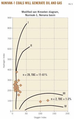
Hydrogen index (HI) ranges from 158 to 379 and averages 240. HI increases with depth in the well (Fig. 9), and eight samples of Late Paleocene rocks below 10,200 ft TVD have an average HI = 284.
On a modified van Krevelen diagram (Fig. 9), the coaly samples form a hydrogen-rich trend indicating potential to generate either oil or mixed oil and gas.
A Miocene siltstone (7,210 ft) and claystone (7,510 ft) plot midway between inert (Type IV) and gas-prone (Type III) in Fig. 9. Most of the coaly samples can be characterized geochemically as excellent oil-prone source rocks.3 The rich coal at 10,810 ft with TOC = 49.88% and HI = 379 highlights the potential for very attractive oil source rocks in deeper parts of the Nenana basin.
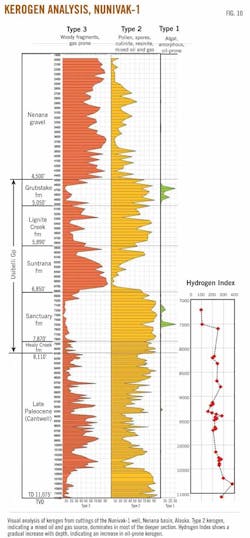
Fig. 10 shows visual estimates of kerogen composition in cuttings from Nunivak-1. Visual estimates in general confirm the geochemical results. Kerogen in the Nenana gravel is mostly Type III, whereas Type II predominates, sometimes strongly, in the Usibelli Group and Late Paleocene.
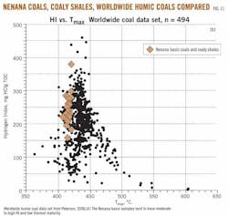
Coals and coaly shales from Nunivak-1 are compared with a worldwide dataset of more than 500 oil-prone humic coals4 in Fig. 11. Nenana basin coals have low maturity, as measured by Tmax, and moderate to high HI values. Based on this data set, Petersen4 estimates the effective oil window for Cenozoic oil-prone coals begins at Ro = 0.65. At this maturity, Petersen4 suggests Cenozoic oil-prone coals are saturated with hydrocarbons and oil expulsion begins.
Estimates of thermal maturity indicate the rocks in Nunivak-1 are mainly immature. Table 1 shows six vitrinite reflectance (Ro) analyses with the deepest sample at 10,420 ft yielding Ro = 0.62. Spore color suggests thermal immaturity with colors ranging from pale yellow at shallow horizons to orange below 8,080 ft. The small RockEval S1 peaks (Table 1) suggest the deepest coals in Nunivak-1 (11,080 ft TVD) are still immature. Trace oil shows noted on the mud log below 9,200 ft are thought to reflect the beginnings of oil generation.
Based on measured and reconstructed well temperatures, the geothermal gradient in Nunivak-1 is estimated to be about 1.5° F./100 ft, a value that approximates continental average. This is based on a surface temperature of 35° F. and a reconstructed formation estimate of 205° F. at 11,075 ft.
Geohistory and basin potential
Platte River Associates used the stratigraphic and temperature data from Nunivak-1 to construct a 1D thermal and maturation model of the deepest part of the Nenana basin.
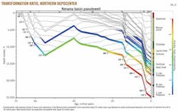
The stratigraphy in Nunivak-1 was expanded to populate a basin center pseudowell to 25,000 ft. Heat flow of 48mW/m2 from 65 to 13 million years was used, then increasing to 59mW/m2 at present. The source characteristics from Nunivak-1 (Table 1) were used to calculate oil volumes.
The maturation results from the basin center pseudowell are shown in Fig. 12. Early maturation around 55 million years depends on about 5,000 ft of sediment deposition and subsequent erosion in the early Eocene, but this history is very poorly constrained. Thermal maturation of most horizons occurs after about 20 million years and continues to the present. From Fig. 12, the top of the transformation window today is estimated at about 12,000 ft.
Source oil expulsion calculations were made by Platte River Associates using 40% Type II kerogen with maturation kinetics similar to the Paris basin and 60% Type III kerogen with maturation kinetics similar to the oil-prone coals of the Mahakam Delta, Indonesia. This integrated source rock was assigned HI = 240, a value identical to the average coal and coaly shale in Nunivak-1.
Assuming TOC = 25%, a conservative value less than the average of 38% for Late Paleocene samples from Nunivak-1, this source will expel oil at about 1,959 bbl/acre-ft. If each of the 27 coaly RockEval samples from Nunivak-1 represents 1 ft of source rock, 27 ft of source will expel about 34 million bbl/sq mile. The gravity inversion depth map (Fig. 3) shows about 240 sq miles where sedimentary rocks are below 15,000 ft in the part of the Nenana basin north of the Nunivak-1 well, and 27 ft of source rock over 240 sq miles would expel 8.1 billion bbl of oil or oil equivalent. These large expulsion volumes are clearly sufficient to potentially charge giant fields.
Alternatively, the eight deepest samples, all below 10,800 ft, have an average HI of 284. An integrated source model of 85% Type II and 15% Type III kerogen has an HI = 285 and expels oil at 2,338 bbl/acre-ft. If each sample represents 2 ft of source rock, then 5.7 billion bbl of oil or oil equivalent is potentially expelled in the northern Nenana basin. Deeper portions of the basin south of Nunivak-1 were not assessed and have additional potential.
Regional potential
The presence of excellent oil-prone source rocks in the Nenana basin allows a more optimistic evaluation of other interior Alaska rift basins. Deep nonmarine rift basins, such as the oil-rich Bohai basin in northeastern China, often contain oil-prone lacustrine source rocks deposited in deep, stratified and anoxic lakes. Similar lacustrine source rocks may exist in the Alaska rift basins, possibly in addition to the coaly source rocks encountered in Nunivak-1. Deep, stratified and anoxic lakes are most likely to form during the initial rifting phase when fault movement is greatest. The presence of lacustrine source rocks in the deepest parts of these basins would add to the oil charge.
The Yukon Flats contains subbasins similar in depth (~25,000 ft) but considerably larger than the Nenana basin. Outcrop cores from the 1980s around the margin of the Yukon Flats found coal with similar HI contents as Nunivak-1. For example, one coaly shale cored at 70 ft along the southern rim of the Yukon Flats is 1 ft thick with TOC = 34%, HI = 379, and Tmax = 442° C., indicating oil window maturity. This coal is an excellent oil source rock and is assigned "Late Paleocene or (?)Eocene," a similar age to oil-prone coals in the Nenana basin. A slightly deeper coal has TOC = 52.1% and HI = 342, while several additional coals were not analyzed.
The surface microseeps in Nenana basin and Yukon Flats may be sourced by these coaly source rocks. Oil volume in the microseeps is so far too small to geochemically type to the oil source, but correlation may be possible if more concentrated surface seepage is found.
Acknowledgments
Many people and companies contributed to this study. Jim Mery, John Woodman, and Jeff Filut (Doyon Ltd.) provided support, data, encouragement, and discussion. Alicia Orange, Greg Jurkowski, Peggy Gallagher, and Tom Walsh (Petrotechnical Resources Alaska) provided critical data, discussion, and review. David West collected field samples for surface hydrocarbons, and David Seneshen (Vista Geoscience) analyzed the results. Gary Thompson (Thompson Solutions) produced the gravity map and gravity inversion and made the Birch Creek depth interpretation (Getech). Charlie James (Platte River Associates) performed the basin geohistory analysis and expulsion calculations.
References
1. Rowan, E.L., and Stanley, R.G., "The Yukon Flats Cretaceous (?)-Tertiary Extensional Basin, East-Central Alaska: Burial and Thermal History Modeling," US Geological Survey, SIR 2007-5281, 2008, 19 pp.
2. Frost, G.M., and Stanley, R.G., "Compiled Geologic and Bouguer Gravity Map of the Nenana Basin Area, Central Alaska," USGS Open File Report 91-0562, 1991, 30 pp.
3. Stanley, R.G., and Lillis, P.G., "Preliminary Interpretation of Rock-Eval Pyrolysis and Vitrinite Reflectance Results From the Nunivak 1 Well in the Nenana Basin, Central Alaska," AAPG Search and Discovery Article #90125, AAPG Pacific Section Meeting, Anchorage, Alas., May 8-11, 2011.
4. Petersen, H.I., "The petroleum generation potential and effective oil window of humic coals related to coal composition and age," Coal Geology, Vol. 67, 2006, pp. 221-48.
The authors
More Oil & Gas Journal Current Issue Articles
More Oil & Gas Journal Archives Issue Articles
View Oil and Gas Articles on PennEnergy.com
